
The National Gallery of Fine Arts Park: Sculpture Garden and Water-Conserving Model Park
Prepared by Mohammad al-Asad and Lara Zureikat, 2005

Bird's-eye view of the park looking south
Table of contents:
1. Introduction and background information
2. Data collection
3. Program requirements
4. Design elements and the emphasis on water conservation
5. Construction costs
6. Maintenance and upkeep
Introduction and background information
The National Gallery of Fine Arts Park (previously known as the Jabal al-Luweibdeh Park), which was established in 1955, is one of Amman's older public parks (see, Mohamed Rafieh, Assets of the Architectural Identity of Old Amman: Jabal Al-Luweibdeh, 1933 - 1959 (Amman, 2026), p. 55). The park, which occupies an area of about 7,500 square meters, provided a pleasant green space surrounded by residences belonging to what was one of Amman's most elegant neighborhoods.
Over the years, the park had suffered from poor maintenance and neglect, and consequently greatly deteriorated, but had not lost its elegance and charm (figures 1, 2, 3, & 4). In early 2002, The Center for the Study of the Built Environment (CSBE) proposed a project for the rehabilitation and development of the park. CSBE consequently embarked on securing commitments for supporting the project from donors, and also on coordinating with the Greater Amman Municipality, the owner of the park, to obtain their approval and support for the project. CSBE was able to initiate construction work on the park in the Spring of 2004, and the work was completed about a year later, in May 2005 (figure 5). The rehabilitated park, which continues to be open to the pubic, includes outdoor sculpture displays, children's play areas, a performance/exhibition space, a café / restaurant, and model educational gardens demonstrating water conservation landscape practices.
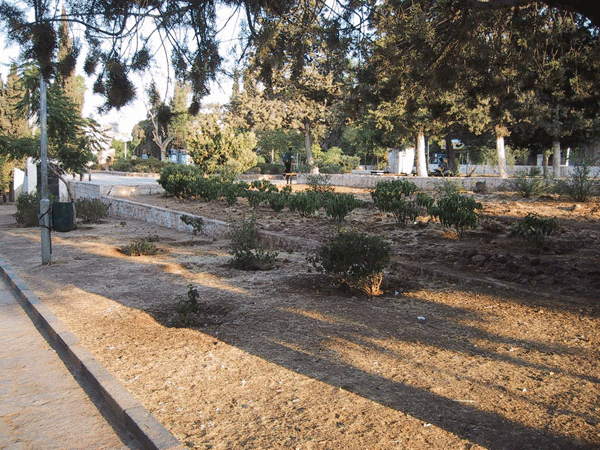
Figure 1: View of lower park area before renovation showing areas in need of planting.

Figure 2: Central area of park before renovation showing mature cypress trees and flagstone paving.

Figure 3: Existing mature trees provide welcome shade during Amman's hot and dry summers.
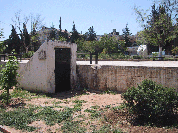
Figure 4: Central area of park in need of a physical pedestrian connection to lower area.
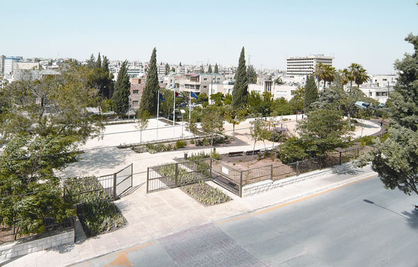
Figure 5: Bird's-eye view of the park looking towards the northeast.
CSBE carried out the rehabilitation of the park as part of its Water Conserving Landscapes project, and in association with the National Gallery of Fine Arts of the Royal Society of Fine Arts.* The Water Conserving Landscapes project was supported by the Water Efficiency and Public Information for Action (WEPIA) program, which was carried in association with the Ministry of Water and Irrigation, and supported by The United States Agency for International Development (USAID). Considerable support for the construction work on the park also was provided by the Greater Amman Municipality and the Ministry of Planning and International Cooperation.
The rehabilitated park now is an integral part of the Jordan National Gallery of Fine Arts, and the park in fact was renamed as the National Gallery Park to emphasize this integral connection. The new park consequently will include installations for outdoor sculptures, to be commissioned and implemented over the next few years. The park also provides a physical and visual connection between the original building of the National Gallery, which is located across the street to the north of the park, and the new extension of the National Gallery, which includes the rehabilitation of an existing building from the 1950s, and is located across the street to the south of the park (figures 6 & 7). A renovation of the original building and the rehabilitation of the extension building were completed at the same time as the rehabilitation of the park. The complete complex was officially inaugurated in May 2005 under the patronage of Their Majesties King Abdullah and Queen Rania.

Figure 6: View of National Gallery extension building before renovation.
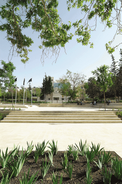
Figure 7: View towards the National Gallery extension building after renovation showing the sculpture platform / performance space and
outdoor seating.
The park also is intended as a model water-conserving park that informs the public about water conserving landscape practices. The park consequently includes a 160 cubic-meter reservoir that has the capacity to harvest rainwater, and that is connected to an efficient drip irrigation system. The park features water-conserving plants that need minimal irrigation and in many cases limited maintenance, as well as gravel-covered areas that require no irrigation (figures 8, 9, & 10). A special turf grass (Bermuda grass) also has been used in one part of the park to minimize water consumption (figure 11).
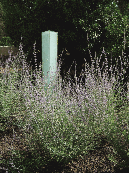
Figure 8: Russian Sage (Perovskia atriplicifolia) with glass prism in background
indicating low water consumption.

Figure 9: Trailing Verbina (Verbina peruviana), a water conserving solution for a colorful ground cover.

Figure 10: Water conserving plant displays and inorganic local mulch known as "tuf" stone.

Figure 11: Bermuda grass turf was chosen for its ability to survive on less water than locally used grass mixes. (photo by Basma Abdallah)
These various features are illustrated by signs and installations that showcase special water-conserving plants. The signs provide data that includes plant names and relevant horticultural information (figure 12). Water consumption indicators in the form of glass prisms also are displayed among the planting displays (figures 13, 14). The signs and installations allow the park to partly take on the role of a water-conserving botanical garden (figure 15).
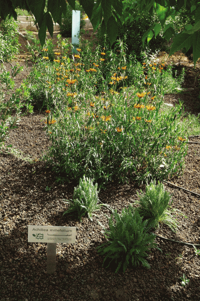
Figure 12: Informational sign showing name and type of plant, sun / shade exposure, water needs, as well as Arabic Water Conserving
Landscapes logo developed by CSBE.
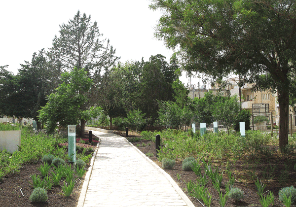
Figure 13: Glass prisms used as an indicator of water consumption: high, moderate, or low.

Figure 14: Detailed view of glass prism used as an
indicator of water consumption: high, moderate, or low.

Figure 15: Water conserving landscapes display showing high water consumption for lawn grass and low water consumption for an attractive green ground cover (Prostrate Thyme).
Other displays of interest include two small gardens located within the park. These are a Japanese garden, designed through the Japanese Embassy in Amman (figure 16), and a Spanish Andalusian fountain designed and implemented through the Spanish Embassy in Amman.

Figure 16: The Japanese garden in the park, mostly composed of stone and gravel, is faithful to the principles of water conserving landscaping.
Data collection
Since this project consisted of the rehabilitation and development of a preexisting park, existing conditions had to be studied before any design decisions could be taken. Before initiating the process of redesigning the park, an extensive physical analysis of the preexisting park was carried out. This included surveying and mapping existing conditions, including existing vegetation, topographic levels, shade and sun patterns, circulation, as well as carrying out a visual assessment of the various components of the park, including its plantings and hard-scaped areas (figures 17, 18, 19, & 20).
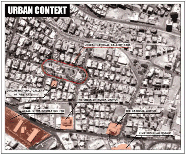
Figure 17: Aerial photograph showing the National Gallery Park within its urban context.

Figure 18: Site plan showing existing conditions and surrounding building types.

Figure 19: Site plan identifying large existing trees.

Figure 20: Site plan showing levels and topography of the park.
The CSBE staff also carried out an observational mapping process of the park as well as interviews with stakeholders. The observational mapping included collecting information on the number of users of the park and their patterns of use of the park, as well as on traffic and parking patterns around the park, all at different times of the day, different days of the week, and different times during the summer and fall months (figures 21, 22, 23, 24, 25, 26, & 27).
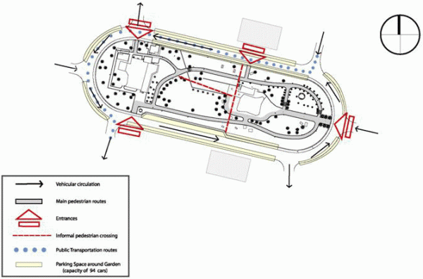
Figure 21: Site plan showing formal and informal circulation patterns.

Figure 22: Site plan showing sun / shade patterns at the park at different times of the day.

Figure 23: Site plan showing an evaluation of existing physical conditions.

Figure 24: Observational mapping plan recording density, location, and age groups of users.

Figure 25: Observational mapping synthesis plan summarizing density and location of users at different times of the day.

Figure 26: Observational mapping synthesis plan summarizing density and location of users at different times of the day.
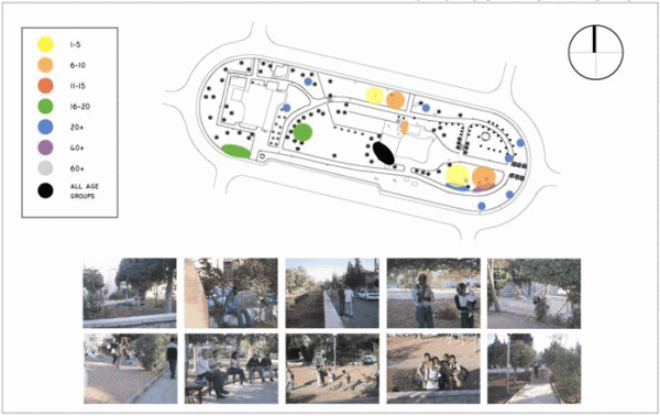
Figure 27: Observational mapping plan summarizing density and location of users according to age group.
Interviews were carried out with various stakeholders including users of the park, residents of the neighborhood, people working in the vicinity of the park, as well as the staff of the National Gallery (figure 28). The interviews and observational mapping allowed the CSBE design team to develop a detailed overview of the various potentials and challenges that need to be addressed in developing the park.

Figure 28: Summary of interviews conducted with stakeholders.
Program requirements
In developing the design of the park, a number of objectives needed to be realized. An emphasis was placed on preserving the original character of the park as a high-quality representative of the evolution of Amman's built environment during the 1950s and 1960s.
The formal aspect of the design also was intended to create a neutral visual setting that would house the outdoor sculptures to be commissioned and installed in the park over the next two years (figures 29 & 30). In addition, the park was to provide an environment that would encourage visitors to learn more about concepts of water conservation in gardens and landscape design. Finally, the park was intended to function as a setting that would encourage various recreational, cultural, and educational activities.

Figure 29: View of sculpture platform and outdoor performance space looking east .
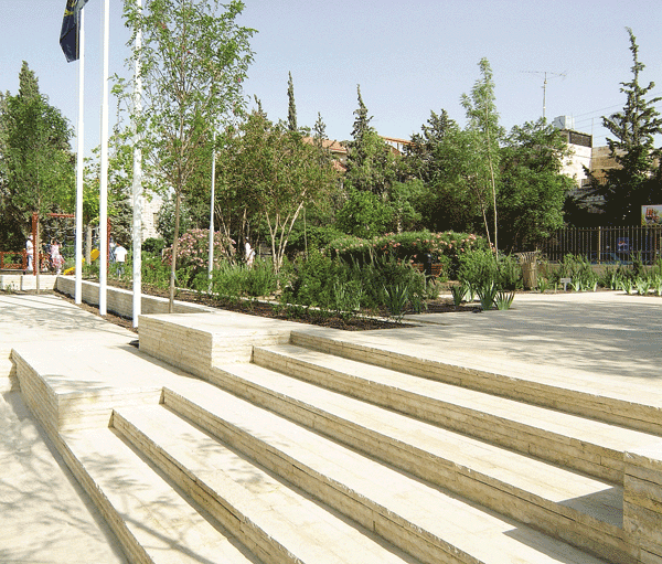
Figure 30: Detail of stair and sculpture platform.
The park also needed to satisfy a number of functional requirements. A major requirement was to provide a visual and physical connection between the original building of the National Gallery located to the south of the park, and the extension building located to its north. The park also was to include areas that would accommodate outdoor sculptures and installations, outdoor performances, outdoor seating for park patrons, a play area for children, as well as demonstrations of water conserving landscapes.
Design elements and the emphasis on water conservation
The design of the park concentrated on a central 250 square-meter platform/performance area, which functions as a focal congregational space within the park, and also provides spatial and functional links between the original building of the National Gallery and the extension building (figure 31). Moreover, this central platform is located over the park's 160 cubic meters rainwater harvesting reservoir, and includes built in stone grills through which the rain water is directed to the reservoir (figure 32).
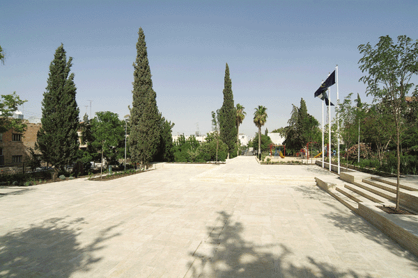
Figure 31: View of sculpture platform and outdoor performance space.

Figure 32: Stone grill covers are placed above two collection points connected to an underground reservoir.(photo by Basma Abdallah)
The central platform incorporates a series of levels to accommodate an area that can function as a stage and also areas for seating. Shade trees have been planted around the platform, and when these reach their full mature size, they will provide the area with considerable shade.
The paths springing out of the central platform area follow the route of the preexisting paths of the old park. The original irregularly-shaped stone panel paving was maintained to provide a visual and textural link to the original character of the preexisting park (figure 33).

Figure 33: View of pathway showing restored original flagstone paving.
The paths leading towards the western end of the park converge onto a semicircular plaza located adjacent to the café/restaurant, which occupies the western part of the park. The café/restaurant was designed and implemented separately from the park, but a level of coordination was maintained between the two components. The Greater Amman Municipality has agreed on an arrangement through which the café/restaurant would be rented out to a private operator, and the rental fees would be paid to the National Gallery to provide this national cultural institution with additional income to support its activities. The plaza and the café/restaurant initially were intended to be integrated visually and functionally, but the operators of the café/restaurant later decided to screen it from the plaza to provide a higher level of privacy for their patrons.
All the original trees and mature ornamental plants of the park were preserved and integrated within the new design. These original plants have been supplemented by a wide range of additional water-conserving trees, ornamental plants, and ground covers (figures 34, 35, & 36).
The use of turf was avoided in the park. Instead, an emphasis was placed on water-conserving plants that function as ground covers and on non-organic ground covers such as the local pumice stone known as tuf. One small area of the park, however, has been covered with Bermuda grass. The idea is that if lawn absolutely has to be used, Bermuda grass is one acceptable solution since it requires less water than most locally used turf mixes. It also can tolerate not being irrigated for long periods without dying off, but only turns brown-yellow under such conditions. Once it is irrigated, the brown-yellow grass blades turn green again.
The park is surrounded by a fence, which is intended for the protection of the park. The park has five gates. Three of these serve as public entrances. The northern and southern gates lead to the National Gallery building and the National Gallery extension respectively (figure 37). The third gate is located to the east of the park. These gates are locked at night. The remaining two gates serve the café/restaurant. One of them functions as the entrance for patrons, and the other is used for service and delivery. The fence has been designed in a manner to allow for complete visual openness between the inside of the park and the area surrounding it.
Construction costs
It is difficult to figure out the exact construction costs for the rehabilitation and development of the park. Support for the construction of the park has come from a series of donors. A number of the construction activities for the park were carried out directly by the donors, and a good part of the support they provided was made as in-kind, rather than cash, support. However, it is estimated that the construction costs for the park (excluding the renovation of the café/restaurant building and the garden surrounding it) amounted to no less than 250,000 JD (about 350,000 $US).
Maintenance and upkeep
The main challenge now that the park is completed is its maintenance and upkeep. The Greater Amman Municipality has dedicated a team for this purpose that would work under the supervision of the National Gallery. CSBE also has developed a comprehensive maintenance checklist for the park to facilitate maintenance and upkeep follow-up. In addition, a stakeholders committee including representatives of the National Gallery, the café/restaurant operator, the neighborhood residents, and those who work in the vicinity of the park, has been formed to follow up in the park.
The National Gallery Park provides a very unique landscaping experience within the context of Jordan. It creates a setting that allows for a variety of educational, cultural, and recreational activities to take place in it. It also can provide a model for the use of planting systems that require little water and little maintenance. It is hoped that this experiment will provide an impetus for the creation of similar parks throughout the country.

Site plan showing initial design of park.
* The Royal Society of Fine Arts is a cultural, non-governmental, non-profit organization, founded in Amman in 1979. It is governed by a board of trustees and has an independent administrative, financial, and legal status. Its goal is to encourage cultural diversity, disseminate artistic knowledge, and promote contemporary art from the Islamic and developing worlds. In 1980, the Royal Society of Fine Arts founded the Jordan National Gallery of Fine Arts. Over the years, the collection of the National Gallery has grown to include over 2000 works consisting of paintings, prints, sculptures, photographs, installations, weavings, and ceramics by more than 800 artists from 59 countries, mainly in Asia and Africa. The museum consequently has the largest collection of artworks by contemporary artists from the developing world anywhere. For additional information on the Royal Society of Fine Arts / the Jordan National Gallery of Fine Arts and the National Gallery's collection, see Wijdan Ali, Jordan National Gallery of Fine Arts (Amman: Royal Society of Fine Arts, 2005).
** The date of the park was originally stated in this article as 1953. This has been modified to 1955, based on the information provided in Mohamed Rafieh, Assets of the Architectural Identity of Old Amman: Jabal Al-Luweibdeh, 1933 - 1959 (Amman, 2026).
PROJECT DATA
The Jordan National Gallery Park
Head Designer: Lara Zureikat, Center for the Study of the Built Environment (CSBE).
Research, Design, and Coordination: Deema Aburizik and Dalia al-Husseini, CSBE.
Designer of Japanese Garden: Masamichi Ozaki.
Designer of Spanish Garden: Local Government of Granada (Spain).
Structural engineer: Ramzi Salfiti.
Mechanical engineer / Irrigation Designer: Majed Sabarini.
Electrical engineer: Fajer Qarrian.
Supervision: Greater Amman Municipality (Sawsan Haddad (Supervising Engineer); Yahia Salameh (Surveyor); and Nabeel al-'Awadi (Foreman)), Mohammad Hisban (Supervising Electrical Engineer), and CSBE (Lara Zureikat and Dalia al-Husseini).
Contractors: Hussein 'Atiyyah (stonework); Mohammad Abu 'Awad (Electrical); Ur Garden (Planting); Qashu' Irrigation & Landscape Contracting (Irrigation); Bilal Shawer (Signage); Artikid (Playground Equipment); and Zalatah Contracting Company (Metalwork).
Photography: Osman Akuz, Basma Abdallah, Dalia al-Husseini, and Lara Zureikat.
Pre-design drawings: Sarah Abdul Majid.
Date of completion: May 2005.
Location: Jabal al-Luwaybdah (Luweibdeh), Amman, Jordan.
Area of park: 7,500 square meters.
Construction costs: Over 250, 000 JD (about 350,000 $US). Amount is an estimate and excludes costs of renovating café/restaurant building and its surrounding garden.
Special thanks are due to the following for the invaluable help they provided in realizing this project: Her Royal Highness Princess Wijdan Ali, President, Royal Society of Fine Arts; His Excellency Nidal al-Hadid, Mayor, Greater Amman Municipality; Dr. Khalid Khreis, General Director, Jordan National Gallery of Fine Arts; Mr. Khalil al-Majali, Director of Public Relations, Jordan National Gallery of Fine Arts; Engineer Ammar Gharaibeh, Director, Works Department, Greater Amman Municipality; Engineer Nibal Qattan, Director, Agriculture Department, Greater Amman Municipality; Engineer Mash'al Halasah, former Director, Follow-up Section, Greater Amman Municipality; Engineer Abdus Salam Kamal, Senior Technical Specialist, Water Efficiency and Public Information for Action (WEPIA) program; and Mr. Susumu Yamashita, Cultural Attaché, Embassy of Japan, Amman.
CSBE implemented the Jordan National Gallery Park project as part of its Water Conserving Landscapes project (Project Director: Mohammad al-Asad; Project Technical Manager: Lara Zureikat).
LIST OF WATER-CONSERVING PLANTS FEATURED IN THE PARK
Abelia x grandiflora Leonotis leonurus
Achillea millefolium Lonicera etrusca
Agapanthus orientalis Myrtus communis
Albizia julibrissin Myrtus communis ‘Compacta’
Buddleia davidii Oenothera speciosa
Buddleia davidii 'Nana' Pennisetum setaceum
Callistemon laevis Perovskia atriplicifolia
Caryopteris x clandonensis Pistacia lentiscus
Ceanothus thyrsiflorus ‘repens’ Platanus orientalis
Cistus x purpureus Plumbago capensis
Cupressus arizonica Robinia pseudoacacia
Cupressus sempervirens Rosmarinus officinalis
Dodonaea viscosa Salvia microphylla
Grevillea robusta Solanum sp.
Iris sp. Sophora japonica
Juniperus horizontalis Teucrium fruticans
Kniphofia uvaria Thymus prostratus
Lagerstroemia indica Verbena peruviana
Lavandula angustifolia Washingtonia robusta
Lavandula pinnata buchii
LIST OF FIGURES
Figure 1: View of lower park area before renovation showing areas in need of planting.
Figure 2: Central area of park before renovation showing mature cypress trees and flagstone paving.
Figure 3: Existing mature trees provide welcome shade during Amman's hot and dry summers.
Figure 4: Central area of park in need of a physical pedestrian connection to lower area.
Figure 5: Bird's-eye view of the park looking towards the northeast.
Figure 6: View of National Gallery extension building before renovation.
Figure 7: View towards the National Gallery extension building after renovation showing the sculpture platform / performance space and outdoor seating.
Figure 8: Russian Sage (Perovskia atriplicifolia) with glass prism in background indicating low water consumption.
Figure 9: Trailing Verbina (Verbina peruviana), a water conserving solution for a colorful ground cover.
Figure 10: Water conserving plant displays and inorganic local mulch known as "tuf" stone.
Figure 11: Bermuda grass turf was chosen for its ability to survive on less water than locally used grass mixes.
Figure 12: Informational sign showing name and type of plant, sun / shade exposure, water needs, as well as Arabic Water Conserving Landscapes logo developed by CSBE.
Figure 13: Glass prisms used as an indicator of water consumption: high, moderate, or low.
Figure 14: Detailed view of glass prism used as an indicator of water consumption: high, moderate, or low.
Figure 15: Water conserving landscapes display showing high water consumption for lawn grass and low water consumption for an attractive green ground cover (Prostrate Thyme).
Figure 16: The Japanese garden in the park, mostly composed of stone and gravel, is faithful to the principles of water conserving landscaping.
Figure 17: Aerial photograph showing the National Gallery Park within its urban context.
Figure 18: Site plan showing existing conditions and surrounding building types.
Figure 19: Site plan identifying large existing trees.
Figure 20: Site plan showing levels and topography of the park.
Figure 21: Site plan showing formal and informal circulation patterns.
Figure 22: Site plan showing sun / shade patterns at the park at different times of the day.
Figure 23: Site plan showing an evaluation of existing physical conditions.
Figure 24: Observational mapping plan recording density, location, and age groups of users.
Figure 25: Observational mapping synthesis plan summarizing density and location of users at different times of the day.
Figure 26: Observational mapping synthesis plan summarizing density and location of users at different times of the day.
Figure 27: Observational mapping plan summarizing density and location of users according to age group.
Figure 28: Summary of interviews conducted with stakeholders.
Figure 29: View of sculpture platform and outdoor performance space looking east.
Figure 30: Detail of stair and sculpture platform.
Figure 31: View of sculpture platform and outdoor performance space.
Figure 32: Stone grill covers are placed above two collection points connected to an underground reservoir.
Figure 33: View of pathway showing restored original flagstone paving.
Figure 34: Water conserving plant displays integrated with previously planted trees. Yarrow (Achillea millefolium) and Lion's Ear (Leonotis leonurus) trees are visible in the foreground.
Figure 35: Existing mature Cypress tree (Cupressus sempervirens) bordered by inorganic local mulch known as "tuf" stone.
Figure 36: Mature Plane Tree (Platanus orientalis) was integrated into a planter between two entry gates.
Figure 37: Southern gate of the park leads to the National Gallery extension building.