
Riyadh Architecture in One Hundred Years
An essay on a public lecture presented by Saleh al-Hathloul at Darat al-Funun, Amman on April 21, 2002
Prepared by Majd Musa with Mohammad al-Asad, 2003
Transcription of Arabic lecture provided by Diala Anabtawi
Download text-only version of this essay
(PDF format, file size is 260 KB)
Support for the publication of this essay has been made possible by a grant from the Prince Claus Fund for Culture and Development. Additional support has been provided by Darat al-Funun - The Khalid Shoman Foundation and the Architectural Section of the Jordan Engineers Association


Table of contents:
2. Riyadh: A Historical background
3. Riyadh’s Development during the first half of the Twentieth Century
4. Riyadh'S Development during the Second Half of the Twentieth Century
4.1 Riyadh's Development during the 1950s and 1960s
4.2 Riyadh's Development in the Seventies, Eighties, and Nineties
Introduction
In this Arabic-language lecture, Saleh al-Hathloul (1) discussed the urban development of the city of Riyadh (2), the capital of the Kingdom of Saudi Arabia, during the course of the twentieth century. A great number of building and construction projects took place in Riyadh during this period, and thus, notes al-Hathloul, it is almost impossible to present these projects in detail in such a relatively short-time lecture. He divided this period of Saudi Arabia's architectural development into two segments, tackling the issue of Riyadh's development on two levels. In the first segment, which extends from the beginning to the middle of the twentieth century, al-Hathloul concentrated on the city's urban development. In the second period, which extends from the middle to the end of the twentieth century, he deals with the urban developments that took place during the 1950s and 1960s, and concentrated on individual building projects that were built since the 1970s.
Riyadh: A Historical background
Riyadh's rise as an urban center began in 1824, when Turki bin ‘Abdallah bin Muhammad bin Sa'ud (r. 1824 -1834), the founder of the second Saudi state (1824 - 1891), established his control over the city and made it his capital. Dir'iyah, which is located some 20 kilometers northwest of Riyadh, was the capital of the first Saudi state (1744 - 1818) (3). Before 1824, Riyadh consisted of a number of small villages that spread throughout the area of Wadi Hanifa. Riyadh underwent another period of growth beginning in 1902, when it was restored by King ‘Abd al-‘Aziz bin ‘Abd al-Rahman Al Faisal Al Sa'ud (r. 1902 - 1953; often called Ibn Sa'ud), the founder of the third Saudi state, which evolved into the present-day Kingdom of Saudi Arabia. Thus, Riyadh, notes al-Hathloul, is a twentieth century city. It has grown from an area of one square kilometer and a population of 14,000 people in 1902 to an area of 1,500 square kilometers and a population of 4,300,000 people in 2000 (4).
Riyadh's Development during the first half of the twentieth century
Al-Hathloul went on to present the old city of Riyadh as it appeared in the early twentieth century (figure 1). The one-square-kilometer city was enclosed by defended city walls (figure 2). The walls were built of mud and bricks, had a height of almost 8 meters, and incorporated towers and defended gates. One of the main structures located inside the walls of Old Riyadh is al-Masmak Fortress (also called al-Masmak Palace; figure 3), which was the first part of the city to be overtaken by King ‘Abd al-‘Aziz in 1902, and which was renovated in recent times (5). Qasr al-Hukm (the Justice Palace; figure 4), the seat of King ‘Abd al-‘Aziz, is located in the center of the old city. Al-Masjid al-Jami' (the Congregational Mosque) of Old Riyadh, which often is referred to as Jami' Turki bin ‘Abdallah (the Mosque of Turki bin ‘Abdallah), was located close to the palace, a common arrangement in traditional Islamic cities. Furthermore, the mosque was linked to the palace by means of a bridge. The center of Old Riyadh, notes al-Hathloul, was rebuilt more than once over the course of the past one hundred years, as shall be seen below. Close to the palace and mosque, the Ministry of Finance as well as other governmental buildings were constructed. However, those were torn down during the early years of the second half of the twentieth century. Sahat al-‘Adl (the Justice Square (figure 5) is a major urban space in the center of the old city of Riyadh, where commercial and communal activities used to take place.
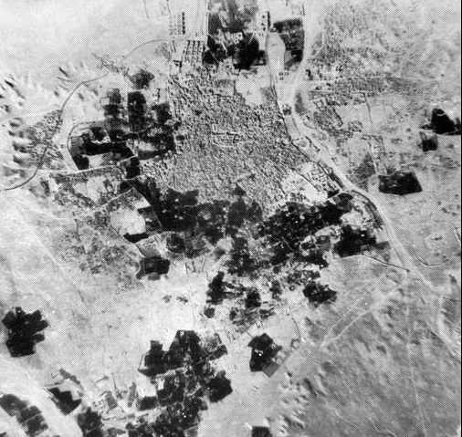
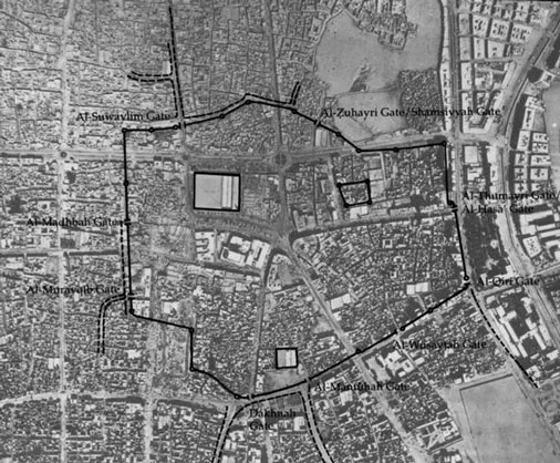
Figure 1: Top: an aerial view of the city of Riyadh in the early twentieth century; bottom: an overlay of the walls of Old Riyadh superimposed on a more recent aerial view of the city
Figure 2: A layout plan of the urban fabric of Old Riyadh showing the city walls, gates, and some major places in the city.
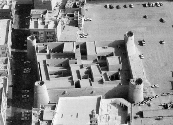
Figure 3: An aerial view of the early-twentieth-century al-Masmak Fortress in Old Riyadh.
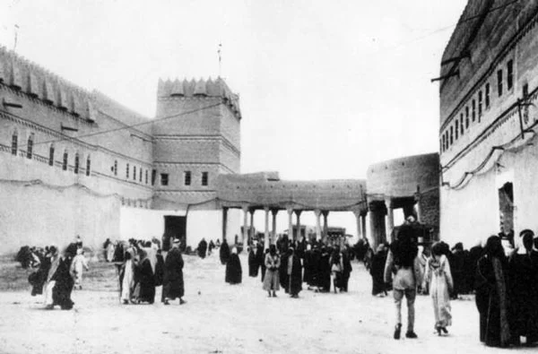
Figure 4: A view of the early-twentieth-century Qasr al-Hukm (the Justice Palace) in Old Riyadh.
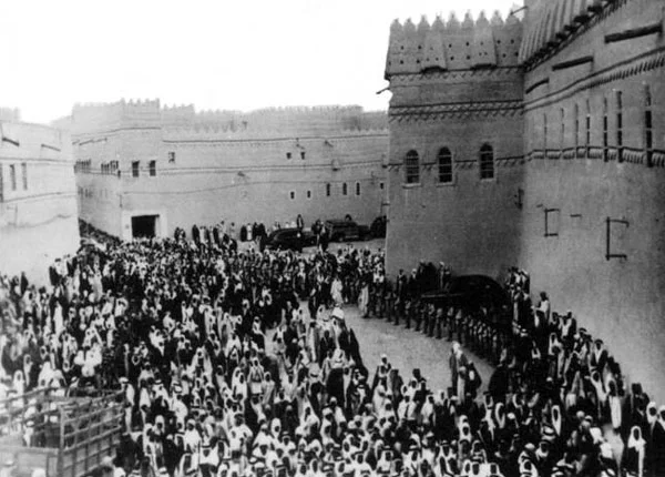
Figure 5: A view of the early-twentieth-century Sahat al-‘Adl (the Justic Square) in Old Riyadh.
Al-Hathloul mentioned that in the mid 1930s, Riyadh extended for the first time outside the walls of the old city. This was marked by the construction of Qasr al-Murabba' (al-Murabba' (the square) Palace), in which King ‘Abd al-‘Aziz established himself in 1937. The palace was located some 2 kilometers to the north of the old city of Riyadh and extended over an area of 16 hectares. It gained its name "al-Murabba' (the square)" from its square 400 by 400 meter form. Al-Murabba' was a kind of walled palatial complex that included a few palaces for the king and members of his family, a few residential buildings that housed the king's retinue, and some administration buildings (figure 6). The construction of al-Murabba', notes al-Hathloul, encouraged the development of the area known as al-Futah, which is located between al-Murabba' and the old city, along the western side of the street that later connected al-Murabba' with Old Riyadh. The development of al-Futah dates to the 1940s, when a few of the sons of ‘Abd al-‘Aziz decided to build their palaces there.
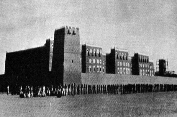
Figure 6: A view of the 1930s Qasr al-Murabba' (the Square Palace), located north of Old Riyadh.
Al-Hathloul added that the construction of al-Murabba' Palace had a strong impact on the physical development and growth of Riyadh. The city expanded considerably. Also, al-Murabba' itself was sizable, and occupied an area almost one-third that of Riyadh. In addition, its construction resulted in the emergence of al-Futah area. Also, by locating al-Murabba' to the north of the old city, northward expansion was set as the primary direction for the growth of Riyadh. Furthermore, the construction of al-Murabba' outside the city walls demonstrated that living within the walls was no longer a necessity, and that citizens would be safe and secure living outside the walls. Thus, building expansion beyond the city walls was initiated.
Al-Hathloul noted that three new technologies were introduced for the first time in Riyadh with the construction of al-Murabba'. The first is the automobile as means of transportation. Consequently, the streets inside al-Murabba' were widened to allow for vehicular movement. However, the later introduction of the automobile to the old city of Riyadh had negative consequences, as some of the buildings of Riyadh were torn down to allow for the widening of streets. The second technology was electricity, which was made available through the use of generators. The third technology was water closets with sophisticated drainage systems.
An important point concerning the construction of al-Murabba' is that although it incorporated these three new technologies, it retained much of the general features of the traditional urban patterns of the central Arabian region of Najd, which included solid masses, covered streets, and the incorporation of courtyards (6). Also, it was built using local Najdi building techniques and materials. Therefore, clay and sun-dried mud bricks were used for the construction of walls, and Tamarisk tree (7) trunks plastered with mud were used for the roofs. Being of much larger size than any other earlier building in Riyadh, al-Murabba' provided a positive example of how one can adapt and apply a traditional building technology to large-scale projects. It was only around 1950 that the departure from traditional building techniques took place in Riyadh. This was with the construction of a rural palace in al-Nasriyah Farm, located to the west of Old Riyadh. The palace probably was the first building in Riyadh in which reinforced concrete was used. Also, an orthogonal grid planning pattern was introduced in al-Nasriyah in 1953 and in the later-project of al-Malaz, which, in turn, influenced city planning practices in Riyadh, as shall be discussed below. A more direct effect of al-Nasriyah on the development of Riyadh was the expansion of the city some 6.5 kilometers to the west.
Al-Hathloul noted that the two projects of al-Murabba' and al-Nasriyah necessitated that they should be linked to the walled city of Riyadh as well as to each other. Thus, in 1953, the first street that linked al-Murabba' with al-Nasriyah was constructed and paved with stones (not asphalt). Also, in the 1950s, a small airport was constructed in the northern part of Riyadh. Moreover, a railway that linked Riyadh with Dammam in eastern Saudi Arabia was inaugurated in 1951. (Figure 7) shows the locations of the old city of Riyadh (no. 1) and the major projects that brought about the city's expansion beyond its walls, including al-Murabba' (no. 2); al-Nasriyah (no. 3); and al-Malaz (no. 4). Another development that took place during the early 1950s was the rebuilding of al-Masjid al-Jami' and Qasr al-Hukm, discussed above, (figure 8) as part of the redevelopment of the old city center to meet Riyadh's accelerating economic growth.
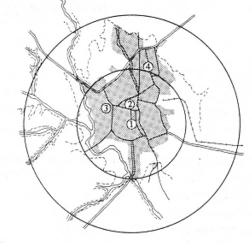
Figure 7: A site location plan of Old Riyadh and the major projects that took place in Riyadh during the first half of the twentieth century.

Figure 8: Al-Masjid al-Jami' (the Congregational Mosque) and Qasr al-Hukm as rebuilt in the early 1950s.
Riyadh's Development during the Second Half of the Twentieth Century
Riyadh's Development during the 1950s and 1960s
Al-Hathloul went on to discuss the development of Riyadh during the second half of the twentieth century. Upon the succession of king Sa'ud Bin ‘Abd al-‘Aziz to the throne of the kingdom in 1953, he took two major decisions that played a major role in the further expansion of Riyadh. King Sa'ud ordered the transfer of the Kingdom's government offices from Mecca, which is located in the Western Province of Saudi Arabia, and which until that time was considered the religious and administrative capital of the kingdom, to Riyadh. Subsequently, a group of buildings were constructed along the airport road (King ‘Abd al-‘Aziz Street) in Riyadh to house the different ministries. The Egyptian Architect and planner Sayyid Kurayyim (8) designed the buildings, and the Egyptian contracting company the Arab Contractors constructed them. (Figure 9) In order to house the employees of those ministries who moved from Mecca, a large-scale housing project was needed. Thus, al-Malaz project, which later came to be known as al-Riyadh al-Jadidah (The New Riyadh), was constructed some 4.5 kilometers northeast of the city center. (Figure 10) Al-Malaz covers an area of almost 500 hectares and consists of around 750 villas, three apartment buildings, as well as the necessary supporting facilities. Al-Hathloul adds that living in apartment buildings was a new concept that was only introduced to Riyadh during the mid-1950s through al-Malaz project. The case is different in al-Hijaz, or the Western Province of the kingdom, which includes Mecca, Medina, Jeddah, and Ta'if, where apartment buildings ranging from two to five stories had been a common residential building type. In Mecca, for instance, residential buildings often were situated close to the Holy Sanctuary, and in Medina, close to the Mosque of the Prophet. They often consisted of more than one story and were designed in a way that allowed them to be divided into separate apartments. During the Muslim pilgrimage season, the owners of those buildings would move to the upper floors of their buildings, or possibly completely evacuate them, and rent them out as apartments to visiting pilgrims.
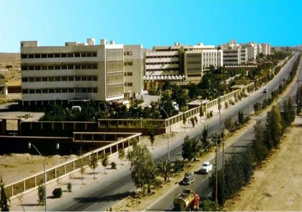
Figure 9: A view of the 1950s ministries' buildings along the airport road (King ‘Abd al-‘Aziz Street) in Riyadh, designed by Sayyid Kurayyim

Figure 10: A layout plan of al-Malaz Housing Project (known as al-Riyadh al-Jadidah), located to the northeast of the old city center of Riyadh.
The second decision that King Sa'ud took and that had an impact on the physical growth of Riyadh was the reconstruction and considerable expansion of al-Nasriyah in the mid 1950s as a royal complex that included a number of palatial residences, a group of villas, and a number of residential buildings as well as other necessary facilities.
According to al-Hathloul, the three projects of ministries' buildings, al-Malaz housing, and the rebuilding of al-Nasriyah had a great impact on the architectural and urban development of Riyadh and the kingdom in general. These projects, particularly al-Malaz, introduced a new way of thinking in terms of planning and construction in the city. First of all, the gridiron planning that was adopted in both al-Malaz and the reconstruction of al-Nasriyah was a clear departure from the traditional urban pattern of Riyadh, which, as is the case with other traditional Islamic cities, was characterized by a labyrinthine urban pattern. Al-Hathloul notes that it was the use of the gridiron pattern of planning in al-Malaz project that served as a model in the more recent planning projects for Riyadh. After all, al-Nasriyah was a palatial residence enclosed by walls, and therefore was unlikely to be taken as a planning model for residential neighborhoods in the city.
Another important building type that emerged from al-Malaz project as a new model for residences in the city was the detached villa (9). According to al-Hathloul, in the 1950s and 1960s, government employees were considered of high social standing and the general public often emulated their way of living, including the way their residences looked. Also, since al-Malaz project was initiated by the government, people considered it an authoritative statement regarding the way their dwellings should look. Therefore, as soon as government employees moved to their new villa-type dwellings in al-Malaz, this building type quickly spread in Riyadh. Also, land prices in Riyadh rose dramatically in the 1960s and 1970s as a result of land speculation. Al-Hathloul believes that this was facilitated by the grid-planning pattern in Riyadh, which had become well established by the introduction of the 1972 Riyadh master plan (see below).
Along with the spread of grid planning and the villa building type, building ordinances and zoning regulations in Riyadh started to be set up. Those ordinances and regulations adopted some issues that already had been incorporated into al-Malaz project, such as the hierarchic pattern of streets, the square lots on which villas were built, and the setbacks on all sides of the lot. With this institutionalization of building ordinances, both grid planning and villa-type dwelling assured their continuity in Riyadh and in other cities in the kingdom.
By the late 1950s, the apartment building started to spread in Riyadh. With the growth of the city, there was a need to bring in expatriates to work in the different sectors of the government. Unlike Riyadhis, who preferred living in detached dwellings, expatriates primarily lived in apartment buildings primarily for economic and social reasons, and al-Malaz project had by then established a precedent for the construction of apartment buildings that could be followed. Among the first apartment buildings to be constructed in Riyadh were the 1959 six-story building of Fahd bin Muhammad (figure 11), which overlooked al-‘Adl Square, and its contemporaneous ten-story al-Riyadh Building, which was situated along al-Wazir Street (currently called King Faisal Street). In the design of these two buildings, the concept of privacy was given importance. The buildings looked on to public areas, such as a square or a wide main street, but they did not look on to the close by one- or two-story high single-family houses. The sides of the buildings that faced neighboring houses were retained for services and staircases, and window openings there were limited and located above eye level so as not to invade the privacy of the neighbors.
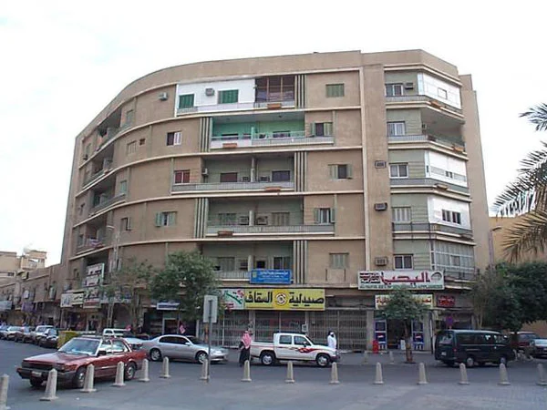
Figure 11: A view of the 1959 Fahd bin Muhammad's apartment building, one of the early apartment buildings constructed in Riyadh.
Al-Hathloul mentioned that in the late 1960s, the design of apartment buildings took a different direction that departed from these privacy conventions. In this context, al-Hathloul showed the example of Zahrat al-Riyadh Building (the Flower of Riyadh Building; figure 12), which was situated at one of the corners of a crossroad. In this building, the designer applied a typical façade that incorporated large windows and balconies to all four sides of the building, paying no attention to what the building looked on to. In fact, the rear façade of the building looked on to the traditional al-Futah neighborhood, which was characterized by houses that were no more than two stories high, and thus violated the privacy of al-Futah residents. Prior to the construction of Zahrat al-Riyadh Building, the residents of single-family houses would complain to the court whenever a high-rise building violated their privacy and the courts used to rule in their favor. However, this time the case was different. By the time Zahrat al-Riyadh was under construction, the powerful long-time residents of al-Futah neighborhood had moved out, and the complaints of the less influential residents of the area were not enough to stop the construction of the building or even to alter the arrangement of its windows and balconies to secure privacy for the neighbors. Thus, Zahrat al-Riyadh Building unfortunately succeeded in establishing a precedent in which objecting privacy violations was no longer legitimate. Consequently, residents of single-family houses in Riyadh had to develop new architectural solutions to their residences that would assure the protection of their privacy (10).
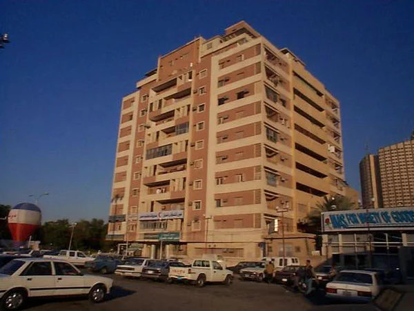
Figure 12: A view of the late-1960s Zahrat al-Riyadh apartment building.
Al-Hathloul mentioned a number of projects that influenced building directions and architectural taste in Riyadh during the late 1960s and early 1970s. Those include the Riyadh Water Tower (figure 13), the Intercontinental Hotel, the Equestrian Club (figure 14), and King Faisal Specialized Hospital.
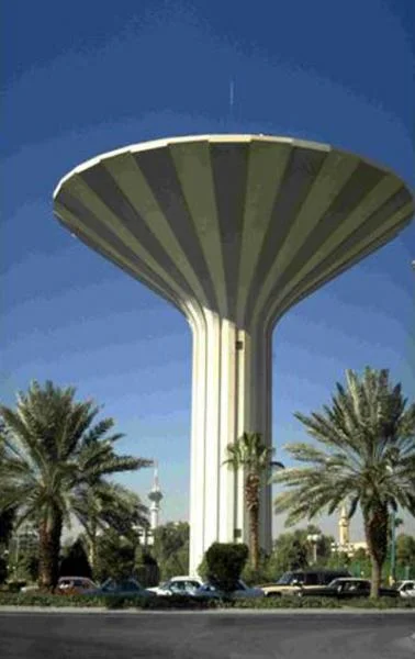
Figure 13: A view of the late 1960s - early 1970s Riyadh Water Tower.
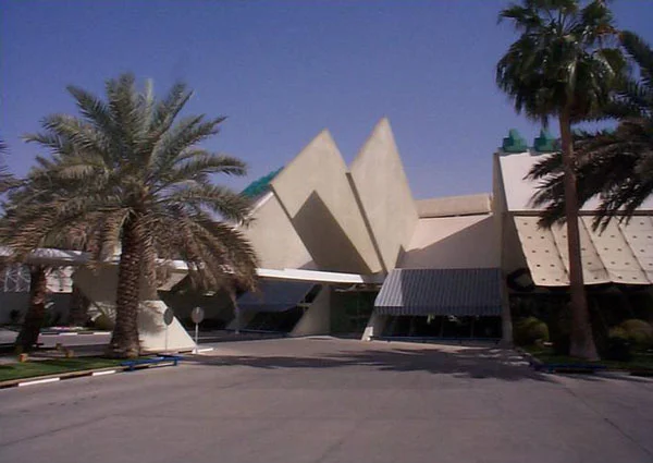
Figure 14: A view of the late 1960s - early 1970s Equestrian Club in Riyadh.
Al-Hathloul went on to describe a major planning project that took place in Riyadh almost at that same period, which is the Riyadh Master Plan. In 1968, the High Committee of the Evaluation of the Riyadh Master Plan, which later evolved into Ar-Riyadh Development Authority (11), was established under the presidency of Prince Salman bin ‘Abd al-‘Aziz, the governor of the Riyadh region, to supervise the master plan project. The task of preparing the master plan and relevant studies, which aimed at controlling and directing the growth of the city up to the year 2000, was assigned in 1968 to the Greek firm Doxiadis Associates. The Doxiadis Master Plan for Riyadh (figure 15), which was completed in 1972, followed the grid pattern that was, more or less, aligned along the north-south and east-west directions. The planner believed that 2 by 2 kilometers is the most suitable area for a neighborhood, and set up the grid on that basis. The plan assumed that the city would expand within a 10-kilometer-radius circle. It determined Wadi Hanifa as a natural limiting boundary to the expansion of the city from the west, and proposed an industrial zone as an artificial boundary for the city's expansion from the east. Basically, the master plan established a north-south longitudinal central spine along which commercial uses would extend, and another spine, perpendicular to the first one, along which institutional and governmental buildings would be located. According to this master plan, residential neighborhoods would extend behind the longitudinal spine (12).
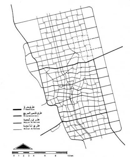
Figure 15: The 1972 master plan for Riyadh, designed by Doxiadis Associates.
The Doxiadis Master Plan for Riyadh adopted the car as the main means of transportation. Thus, Streets were designed in a hierarchic pattern that included freeways that link the city with other regions in the kingdom; expressways that serve high-speed traffic inside the city of Riyadh; arterial streets that serve heavy-traffic inside the city; collector streets that link the neighborhoods together; and local streets that run inside the neighborhoods.
The Doxiadis Master Plan for Riyadh was at a later stage upgraded by the French planners SCET - International. However, the main features of the original master plan, primarily the 2 by 2 kilometer grid, were maintained. Al-Hathloul noted that as Riyadh needed to expand, it extended eastwards and northwards, and that the grid pattern allowed too much undesirable horizontal expansion of Riyadh.
Riyadh's Development in the Seventies, Eighties, and Nineties
Riyadh witnessed a tremendous construction boom during the 1970s and 1980s as a result of the rise in oil prices in the 1970s. At that time, Newsweek Magazine described Riyadh as "the biggest construction site in human history." In fact, during the decade extending from 1977 to 1986, an average of 11,500 building permits were issued in Riyadh each year.
Al-Hathloul presented some of the buildings that belong to this period, particularly pioneering projects that he believes influenced the evolution of architecture in Riyadh. He started with the buildings of the General Organization for Social Insurance, which were constructed in two phases (figure 16). The first phase of this project, which was designed by the Saudi Arabian consulting firm Omrania & Associates, was completed around 1973. This phase of the project seems to have been influenced by the Boston City Hall building (1963 - 1968). In 1982, the second phase of the project was constructed to include a building that is triangular in plan and connected to the original building at the levels of the first and second stories. The long side of the second-phase building was placed opposite to the original building. A curtain wall of reflective glass was applied to most of the façade located along the building's long side. The curtain wall acts as a mirror that provides a reflection of the first-phase building. The curtain wall is crowned with sun shading devices identical to those located at the upper part of the first-phase building. The southern facade of the second-phase building is basically solid, and simple sun shading devices were applied to the window openings in the building's western façade (13).
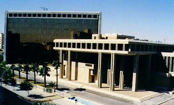
Figure 16: A view of The General Organization for Social Insurance Buildings, designed by Omrania & Associates
Al-Hathloul also presented the 1978 Saudi Arabian Monetary Agency Head Offices (figure 17), designed by the well-known American architect Minoru Yamasaki (1912 - 1986). Sun shading devices, which extend along the height of the building, dominate its main façade (14). He also discussed the 1980 six-story building of the Saudi Fund for Development (figure 18), designed by Urbahn and Coile International. According to al-Hathloul, this building presents two important features. The first is that it took on the traditional concept of the introverted Riyadhi residence. Accordingly, the designer developed a central glass-roofed atrium around which the spaces of the building were placed. The second feature is the designer's application of architectural vocabularies common in the traditional architecture of Riyadh and Dir'iyah. These include slit-type windows, of which the uppermost ones were crowned with diagonally placed small square openings. The designers also incorporated some decorative openings into the parapet of the building. Al-Hathloul adds that the designers of this building initiated an approach to façade articulation that later came to be adopted by a number of architects working in Riyadh (15).
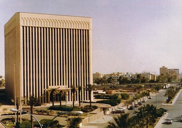
Figure 17: A view of the 1978 Saudi Arabian Monetary Agency Head Office, designed by Minoru Yamasaki.
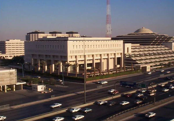
Figure 18: A view of the 1980 Saudi Fund for Development Building, designed by Urbahn and Coile International.
Al-Hathloul considers one of the more outstanding buildings from that period to be the 1982 King Faisal Foundation (known as al-Khayriyya complex; figure 19) designed by the leading Japanese architect Kenzo Tange (b. 1913). Al-Khayriyya complex includes an office building, an apartment building, shopping center, auditorium, and mosque. The complex includes two identical high-rise buildings, which are triangular in plan and situated with their vertices facing each other at a distance that is bridged by two bridges located above each other at the upper part of the buildings. The facades of the two bases of the triangles, one of which faces north and the other south, are clad with glazed curtain walls. The remaining facades are mostly solid. The space between the vertices of the two triangular buildings frames the mosque of the complex. Both the dome and the minaret of the mosque depart from conventional types. Consequently, the traditional dome was replaced by a more or less hollowed cylindrical element cut from the top to serve as a skylight for the interior of the mosque, and the traditional minaret was replaced by a simple tall column-like element that is square in plan (16).
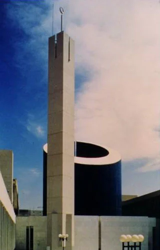
Figure 19: Views of the 1982 complex of King Faisal Foundation (known as al-Khayriyya Complex), designed by Kenzo Tange.
Other important buildings constructed in Riyadh during the 1980s include the Institute of Public Administration (figure 20), which was designed by the American firm The Architects Collaborative (TAC) (17), the 1983 King Khalid International Airport (figure 21) designed by the American firm Hellmuth, Obata + Kassabaum (HOK) (18), and the 1984 campus for the King Saud University (figure 22). The master plan and the conceptual urban design for the university were prepared in the 1970s, but the more advanced phases of the design of the project were carried out later on by HOK in association with the 4 Consortium for Design, Engineering and Construction Administration. The plan of the university comprises two main spines along which the different colleges are arranged. The two spines meet at the forum of the university, which is the central space around which buildings such as the administration, library, and auditorium are placed. The educational buildings are three-story high, and entry to them was provided at the intermediate level, with all services being situated at the lower level(19).
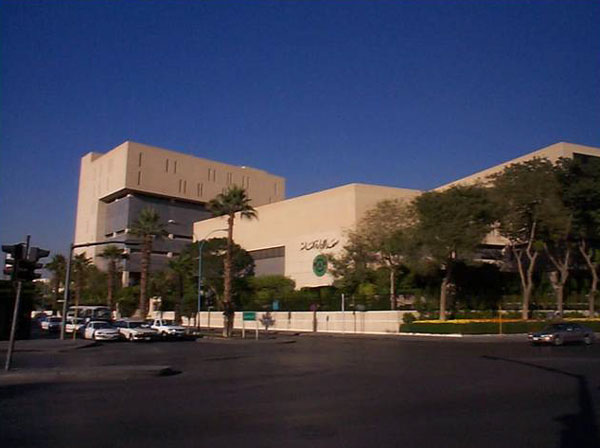
Figure 20: A view of the early-1980s building of the Institute of Public Administration, designed by The Architects Collaborative (TAC).
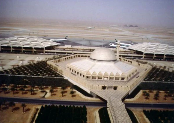
Figure 21: Views of the 1983 King Khalid International Airport, designed by HOK; top: aerial view; bottom: interior view.
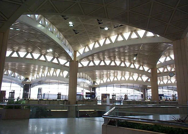
Figure 22: A view of the 1984 campus for the King Saud University, designed by HOK and 4 Consortium.
Al-Hathloul added that the middle of the 1980s marked the formation of a new awareness in Riyadh regarding architecture and building construction. For one thing, a number of Arab and Saudi architects started to play a more major role in the architectural development of the city. Those architects were inspired by the local architectural heritage of Riyadh, and aimed at developing a new architecture that blends the old with the new. Among the notable architects of that period is Basim al-Shihabi, principal of Omrania & Associates. Al-Shihabi, designed in the 1970s (along with architect Nabil Fanous, then affiliated with Omrania) the more or less modern-style building of the General Organization for Social Insurance mentioned above. Al-Shihabi also designed the buildings for the Gulf Cooperation Council (GCC) Headquarters in Riyadh, which evokes the region's traditional architecture (figure 23) (20). Also, the conceptual design of the Tuwaiq Palace (earlier called the Diplomatic Club; figure 24), which was constructed in 1985 in Hayy Assafarat (Embassies' Quarter; often called the Diplomatic Quarter) in Riyadh (21), is the work of Basim al-Shihabi. However, the consequent phases of the project's design were carried out by the OHO Joint Venture (Atelier Frei Otto of Germany, Buro Happold of Britain, and Omrania & Associates). The Tuwaiq Palace serves as a place for governmental functions including official receptions, conferences, and cultural festivals. It also includes some recreational facilities, such as indoor and outdoor sport courts, gardens, and landscaping. The project succeeded in drawing a connection between the past and present. The structure of the project comprises reinforced concrete, limestone clad external walls and tensile-structure, large-scale, white-color tents made of fiber fabric and coated with Teflon. The Tuwaiq Palace received the 1998 Aga Khan Award for Architecture (22).
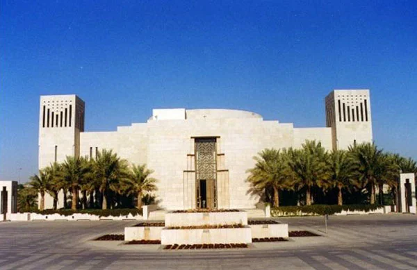
Figure 23: A view of the buildings of the Gulf Cooperation Council (GCC) Headquarters, designed by Omrania & Associates.

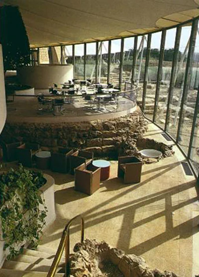
Figure 24: Views of the 1985 Tuwaiq Palace in the Diplomatic Quarter, designed by OHO Joint Venture.
The Saudi Beeah Group Consultants, represented by Saudi architects Ali Shuaibi and Abdul Rahman al-Hussaini, also played a major role in the development of Riyadh's architecture during that period. Their more prominent projects include the urban design for the central spine of the Diplomatic Quarter (1980), the Qasr al-Hukm Urban Design project (1983), and the design of al-Kindi Plaza (1986; figure 25) in the center of the Diplomatic Quarter, which comprises the building of Ar-Riyadh Development Authority and the Friday Mosque, as well as surrounding commercial facilities. In fact, al-Kindi Plaza won the 1989 Aga Khan Award for Architecture. Another distinguished Beeah project is the Regional Office for the Social Insurance Organization in Riyadh (23).
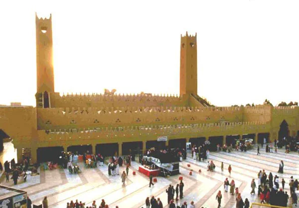
Figure 25: A view of the 1986 al-Kindi Plaza in the center of the Diplomatic Quarter, designed by the Beeah Group Consultants.
Also, Zuhayr Al Fayiz Consultants were among the architects who participated in the development of Riyadh's architecture. Their Ministry of Municipal & Rural Affairs, the design of which was significantly developed by architect Abdulla Suwaylim and others during the construction phase of the project, is one to which al-Hathloul referred as "an oasis in the center of Riyadh" (Figure 26).
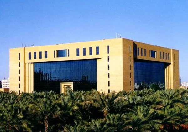
Figure 26: A view of the building of the Ministry of Municipal and Rural Affairs, designed by Zuhayr Fayiz Consultants.
Al-Hathloul added that a number of international architects soon participated in the efforts exerted by Arab and Saudi architects to assimilate the character of local Najdi architecture and introduce it as part of the new architecture of Riyadh. Among the projects that made important contributions in this regard is the King Fahd Stadium, the construction of which was completed in 1987 (Figure 27). The British firm Ian Fraser, John Roberts and Partners designed the stadium as an international FIFA football field that would accommodate around 70,000 spectators. The roof construction of the stadium consists of a number of tent-shaped Teflon-coated fiberglass units supported with cables. Another project consists of the buildings for the Islamic University of Imam Muhammad bin Saud (24), which was designed by the Spanish firm Techniberia Group and completed in the late 1980s. According to al-Hathloul, the designers succeeded in creating an organic plan for the university that responded to a number of factors. The designers created a group of linked courtyards around which the different buildings were placed. The plan therefore responded rather well to both climatic factors and the local architectural heritage of Riyadh. It also succeeded in shortening walking distances between parts of the campus, which is a major issue to be considered in university planning. This was quite a contrast with other universities in Riyadh. In the King Saud University, for example, one needs to walk around 2 kilometers to move from the university's administration building to the furthest school within the university, the School of Agriculture. Al-Hathloul also referred to the 1989 Ministry of Interior (figure 28), which Archisystems and architects Musalli, Shakir, and Mandili designed in the form of an inverted pyramid crowned by a dome. Al-Hathloul added that this building has become one of Riyadh's landmarks, "whether we like it or not" (25).
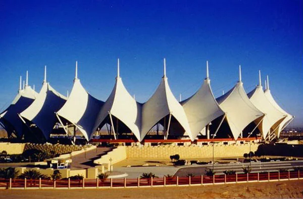
Figure 27: A view of the 1987 King Fahd Stadium, designed by Ian Fraser, John Roberts and Partners.
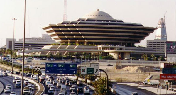
Figure 28: A view of the 1989 Ministry of Interior, designed by Archisystems and architects Musalli, Shakir, and Mandilli.
Al-Hathloul moved on to discuss the significant role that Ar-Riyadh Development Authority played in the architectural development of Riyadh (26). The authority undertook many projects, the most important of which are the Diplomatic Quarter, the buildings of the Ministry of Foreign Affairs and the Ministry's Staff Housing, the Redevelopment of Riyadh's Old Center, and the King Abdul Aziz Historical Center. Al-Hathloul started with the Diplomatic Quarter project. In 1975, the Saudi government made the decision to relocate to Riyadh foreign embassies and the Ministry of Foreign Affairs. These had been located in the city of Jeddah, which was viewed as a socially more open environment than the conservative Riyadh. Since Riyadh did not have the necessary facilities to receive this influx of institutions, a new quarter in what was then the outskirts of Riyadh was set aside to house the different ambassadorial missions. Thus, Ar-Riyadh Development Authority started to prepare the plan for the Diplomatic Quarter, which was conceived as a self-contained neighborhood. An area of around 800 hectares that was placed some 8 kilometers northwest of the old center of Riyadh was assigned for the quarter. The German firm Albert Speer & Partner (AS & P) was the urban planner for the project, the Beeah Group Consultants undertook the urban design for the central area of the project, and architect Farahat Tashkandi was in charge of the redesign of the project's residential area and also was responsible for setting up building regulations and ordinances for the area. The Diplomatic Quarter, was designed to accommodate around 30,000 people and house 120 embassies. Today, it includes around 54 embassy buildings, over 40 public buildings, and a number of residential detached houses and apartment buildings. (Figure 29) shows the site layout for the project, which comprises a main spine of two boulevards between which the commercial area, offices, some governmental services, and the Friday mosque are located. The basic facilities and embassy buildings as well as ambassadors' residences (shown in brown) are located along the main spine. Away from the spine are the residential clusters (shown in yellow). The quarter includes central facilities (shown in red) and public facilities (shown in blue), including kindergartens, mosques, schools, shopping centers, and medical centers (27).
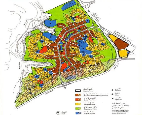
Figure 29: A site layout plan for the Diplomatic Quarter project, urban plan by Albert Speer & Partner.
Al-Hathloul added that the Diplomatic Quarter includes a number of distinguished projects, such as the previously mentioned Aga Khan Award winners, the Tuwaiq Palace and al-Kindi Plaza, the Embassy of Japan, designed by Kenzo Tange, and the Embassy of Tunisia, designed by architects Mimita, bin Mahmoud, and Faraj. The project's landscaping (figure 30), designed by the German landscape architects Bodeker, Boyer, and Wagenfeld also received the Aga Khan Award for Architecture. The internationally acclaimed landscaping of the Diplomatic Quarter was designed to incorporate hardscaping elements from the natural environment, and also used drought-tolerant plants that can withstand both the scarcity of water and the extremely hot climatic conditions of the area (28).
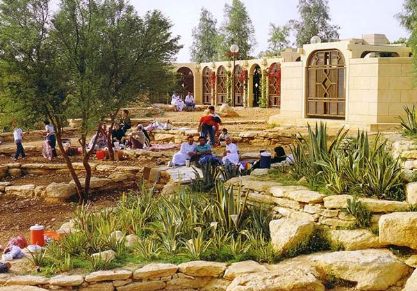
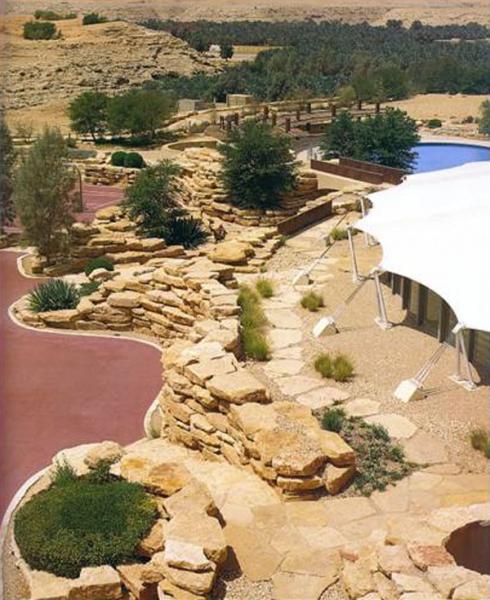
Figure 30: Views of the landscaping of the Diplomatic Quarter, landscape design by Bodeker, Boyer, and Wagenfe
Another important project that Ar-Riyadh Development Authority undertook is the Ministry of Foreign Affairs Staff Housing (Figure 31). The project, which is located 12 kilometers from the center of Riyadh, was designed by Albert Speer & Partner. It extends over a 40-hectare site and comprises detached and semi-detached villas placed on differently sized lots as well as some apartment buildings. It also includes two mosques, shopping centers, kindergartens, clubs, a library, and a police station. The project was designed around a central spine at each end of which is a mosque. The auto-free central spine acts as a recreational area for the neighborhood. The project is served by way of dead-end streets that extend from the main streets, which surround the neighborhood. The cul-de-sacs act as courtyards or open spaces around which the clusters of houses are arranged. Al-Hathloul noted that the Ministry of Foreign Affairs Staff Housing project had a great impact on the development of urban planning in Riyadh, particularly in terms of accepting the idea of cul-de-sacs and creating urban plans that give attention to the needs of pedestrians. Since this project was completed, al-Hathloul notes that municipalities throughout the kingdom have started to follow this model of planning. Those include the municipalities of Riyadh and Medina, the latter which planned a considerable number of residential neighborhoods in the late 1990s encompassing the cul-de-sac concept and catering for pedestrian needs. Also, the Ministry of Municipal and Rural Affairs has followed these concepts in the planning it has carried out for a rather large number of small- and medium-sized towns within the kingdom (29).
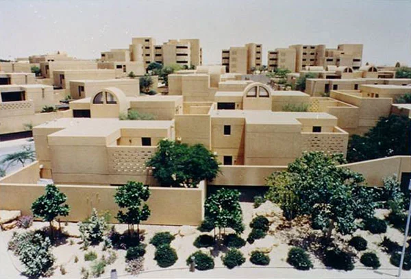
Figure 31: The Ministry of Foreign Affairs Staff Housing project, designed by Albert Speer & Partner.
Among the pioneering projects in Riyadh that Ar-Riyadh Development Authority undertook is the building for the Ministry of Foreign Affairs, which is located some 2 kilometers from Old Riyadh. The Danish firm Henning Larsen designed the building, which was completed in 1984, and which received the 1989 Aga Khan Award for Architecture as well as a number of other international prizes. The exterior of the building with its massive block and small windows resembles a desert fortress (Figure 32). The building's interior is lit through the skylights covering the 4-story-high central atrium as well as the smaller courtyards around which the offices are grouped (30).

Figure 32: A view of the 1984 building for the Ministry of Foreign Affairs, designed by Henning Larsen.
Al-Hathloul also discussed the redevelopment and revitalization of Qasr al-Hukm (the Justice Palace) District in the center of the old city of Riyadh (31). In the mid 1970s, this district was almost vacant as a result of clearing activities that had taken place there. The Italian architect Marco Albini was commissioned to carry out a conceptual urban design for the district. He also was in charge of designing the buildings of the Riyadh Municipality, Riyadh Governorate, and the police headquarters, the three of which were situated in this central area. Towards the end of the 1970s, the Beeah Group Consultants were commissioned to review and update the designs of the three buildings. The Beeah Group Consultants retained the original building designs of Albini, but made some modifications to the internal spaces of the buildings and incorporated the vocabularies of Najdi architecture into the buildings' facades. In 1981, the Beeah Group Consultants also were commissioned to carry out the urban design for the whole Qasr al-Hukm District. The staff members of Ar-Riyadh Development Authority were also involved at a later stage in the modification of the urban design scheme (32).
During the mid 1980s, and as a second phase of the project of the redevelopment of the old city center, the Jordanian architect Rasem Badran (b. 1945) of Shubeilat Badran Associates (later renamed Dar al-Omran) was commissioned to design the buildings for the Great Mosque of Riyadh (figure 33) and Qasr al-Hukm, which were to be located more or less on the same location as the no longer extant al-Masjid al-Jami' (the Congregational Mosque) and Qasr al-Hukm (33). Badran's scope of work also included the urban development of the adjacent public squares, particularly al-‘Adl Square, and streets as well as parts of the walls of the old city. The project, which was completed in 1992, has received a number of prizes including the 1995 Aga Khan Award for Architecture and the 1990 Arab Architecture Award of the Organization of Arab Cities. Al-Hathloul stated that Badran succeeded in recreating the character of the old Islamic city's mosque, not only through incorporating traditional vocabularies associated with Najdi mosque architecture, such as flat roofs, courtyards, arcades, limestone cladding, and slit-type windows surmounted by triangular openings, but also through the mosque's integration into the urban fabric of the old city center in a way that assured its function as a place of worship as well as a main core of commercial and communal activities in that part of the city. Moreover, Badran dealt with the nearby urban spaces in a manner that succeeded in integrating the mosque with its context. This is specifically demonstrated in the solution Badran developed for the differing directions of the qibla (the direction of the Muslim prayer, which faces the city of Mecca) to which any mosque should be oriented, and the street along which the mosque lies. Here, Badran accommodated both directions by giving the mosque its proper orientation and providing arcades along the street façade of the mosque. The arcades, which in some places house shops, act as a transitional area that aligns the mosque with the street. Interestingly enough, Badran maintained the traditional link between the mosque and the Justice Palace by providing a bridge connecting both buildings. Historically, such a connection used to provide a direct path for the governor or the king from the palace, where he stayed, to the congregational mosque, where he performed prayers - particularly the Eid Prayers (34).
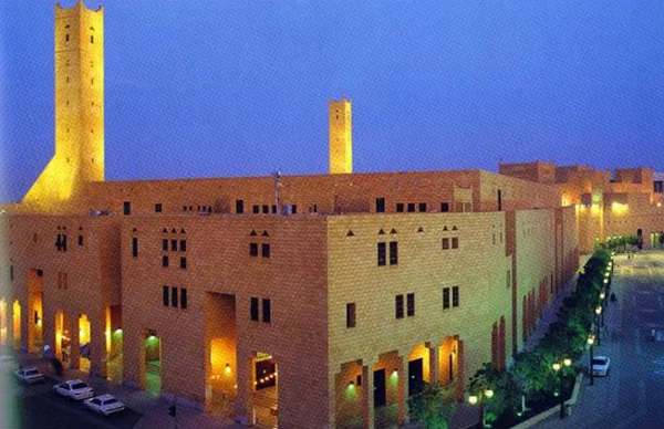
Figure 33: A view of the 1992 Great Mosque of Riyadh in the old city center of Riyadh, designed by Rasem Badran.
The last of Ar-Riyadh Development Authority's projects that al-Hathloul presented is the King ‘Abd al-‘Aziz Historical Center, which is also referred to as al-Murabba' Development project. The King ‘Abd al-‘Aziz Historical Center extends over an area of 37 hectares, and includes conservation works as well as the construction of new buildings. Al-Hathloul added that in this project, Ar-Riyadh Development Authority considered the preservation of as much of the old buildings in the area as possible. However, he pointed out that the problem that one often faces when dealing with the issue of conservation of historic buildings in Riyadh is that traditional buildings basically were constructed of mud, which does not last for long. The Beeah Group Consultants, which were in charge of the conservation work, preserved al-Murabba' Palace, which served as King Saud's residence and later on housed the King's offices, and they remodeled and refurbished a few other old buildings in the area. Some of the historic buildings that could not be preserved were completely rebuilt as replicas of the original ones (Figure 34).
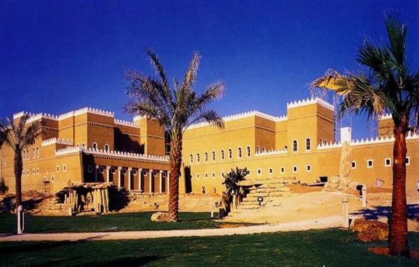
Figure 34: A view of preservation works in the King ‘Abd al-‘Aziz Historical Center, designed by the Beeah Group Consultants.
As for new constructions in the area of al-Murabba', architects Rasem Badran and Ali Shuaibi worked together, along with the staff of the Ar-Riyadh Development Authority who concentrated on the urban design for the area. The timeframe for the project was relatively short - around 13 months - as construction work in the project was supposed to be completed by the 22nd of January 1999, which is the centennial of King ‘Abd al-‘Aziz's recapturing of the city of Riyadh (35). The new buildings in the project include the Saudi Arabian National Museum (figure 35), which was designed by the Canadian firm Moriyama & Teshima Architects with Büro Happold Engineers. The Canadian firm LORD Cultural Resources Planning & Management and the Royal Ontario Museum provided exhibit design and museology services for the project. The 30,000 square-meter project includes galleries, curatorial spaces, and an auditorium as well as outdoor landscaped areas (36). Another important project included in the King ‘Abd al-‘Aziz Historical Center is Darat al-Malik ‘Abd al-‘Aziz (King ‘Abdul ‘Aziz Foundation for Research and Archives). Darat al-Malik ‘Abd al-‘Aziz was partly incorporated into the newly renovated al-Murabba' Palace and partly housed in newly constructed buildings situated close to al-Murabba'. Rasem Badran and Omrania & Associates were in charge of the design of the project (37). Also included in the Historical Center is the King ‘Abd al-‘Aziz Library and Auditorium, which were designed by Omrania & Associates (38). The King ‘Abd al-‘Aziz Historical Center includes extensive areas of landscaping, which were designed by the landscape architects Bodeker, Boyer, and Wagenfeld, and which has the 100-Palm-Tree Square as a central feature.
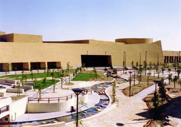
Figure 35: A view of the Saudi Arabian National Museum in the King ‘Abd al-‘Aziz Historical Center, designed by Moriyama & Teshima Architects.
Al-Hathloul concluded by presenting Riyadh's two newest high rises, al-Faisaliah Complex and the Kingdom Center. The 267-meter high al-Faisaliah Tower (figure 36), designed by the well-known British architect Norman Foster and Partners, and completed in 2000, was Saudi Arabia's highest building at the time of its completion. The structure, which has a square plan that tapers to a lantern at the summit, houses numerous functions such as a five-star hotel, offices, and a shopping mall. However, it has been taken over in height by the more recent 300-meter high Kingdom Center tower (figure 37), designed by Omrania & Associates in association with the American firm Ellerbe Becket. The Kingdom Center comprises an elliptical tower that ends at the top in a parabolic opening. The mixed-use tower houses, among other functions, a five-star hotel, offices, department stores, and underground car parks and facilities. Obviously, both buildings depart from a tradition-oriented architectural and urban model to a more or less global one. Undoubtedly, they will have a great impact on future building directions in Riyadh as well as in the other cities in Saudi Arabia (39).

Figure 36: A view of the 2000 Faisaliah Tower, designed by Norman Foster and Partners.
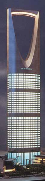
Figure 37: A view of the
2003 Kingdom Center
Tower, designed by
Omrania &Associates with
Ellerbe Becket. (Photo by
Omrania & Associates)
Questions and Answers
The participants raised the issue of past and present approaches to architectural design in Riyadh. Here, one audience member mentioned that during the early years of the twentieth century Riyadh's architecture had its own individual traditional character that continued to prevail until the early 1950s, after which the traditional approach to architecture was dismissed. It was added that the al-Malaz project as well as the ministries' buildings that were constructed in the 1950s were completely alien to the Najdi traditional building style or pattern of urban fabric. This audience member pointed out that when looking at these projects one would not necessarily identify them as belonging to Riyadh, and that such projects easily could have belonged to almost anywhere else in the world. He also added that in the 1960s and 1970s the architecture of Riyadh continued more or less the same "modern" approach to architecture that was initiated in the 1950s. According to this audience member, a turn towards tradition-oriented approach to architecture began to take place in Riyadh with the 1980 Saudi Fund for Development building. Although the architects of this building did not literally copy traditional buildings of Riyadh, they succeeded in drawing connections with the urban and architectural past of the city. The audience member enquired about the reason that Riyadh had to wait so long before an architecture that established connections to its past finally emerged. Al-Hathloul commented that during the 1950s Riyadh was developing at a very rapid rate, and that such a development was beyond the capacity of the Kingdom's local institutions to keep up with. Thus, at that time, when King Sa'ud ordered the transfer of the ministries to Riyadh, there was an awareness that the architects designing the buildings would need to be brought in from abroad. These architects contributed the best architecture they could produce, even though that architecture was not necessarily the best suited for Riyadh. As for the building of the Saudi Fund, al-Hathloul stated that its architects obviously were aware of the basic urban and architectural characteristics of the region and they exerted some effort to include in their design references to traditional Najdi architecture, such as the courtyard (see above).
An audience member enquired about the development of the apartment buildings in Riyadh over the past four decades. He wondered whether new regulations were set to protect the visual privacy of residents of neighboring single-family dwellings as well as apartment buildings. Al-Hathloul commented that as the urban development of Riyadh continued at a very fast rate, the construction of apartment buildings became more and more ubiquitous. As mentioned above, visual privacy rights began to be violated in the late 1960s. This obviously is the case with the construction of the Zahrat al-Riyadh apartment building, discussed above, which violated the privacy of neighboring single-family houses. Al-Hathloul mentioned that King Faisal (r. 1964 - 1975) himself was involved in trying to solve the dispute over the building's violation of visual privacy for nearby residents. He added that the king consequently ordered that the owner of the apartment building should buy any nearby dwellings the owner of which wished to sell because of privacy violation at a price that was ten percent higher than the dwelling's market price at that time. Al-Hathloul noted that although the building regulations and codes set by the Riyadh Municipality during the 1960s and 1970s put forward setback requirements (two meters from neighboring lots and a one-fifth of the width of the street along which a lot is located), those regulations did not ensure privacy protection for residents. According to those building regulations, window openings in the second floor of a building that overlooked a neighboring dwelling were allowed as long as the setback requirements were adhered to. However, al-Hathloul added that whenever a resident whose privacy had been violated complained to the court, the court ruled that windows violating the neighbors' privacy should be blocked up. Thus, issues relating to visual privacy were still taken into consideration during the 1960s and 1970s, but there was a sort of contradiction in the attitude of different institutions (such as the municipalities and the courts) regarding it. According to al-Hathloul, there also was some kind of developmental lag between the traditional building institutions on the one hand, and the new large-scale projects and new building techniques and materials on the other. Therefore, local craftsmen were unable to effectively participate in the construction of the large projects that were constructed in Riyadh in the early 1950s, and therefore did not have any input in them. Consequently, a disconnection between traditional and new approaches to the making of architecture became very evident.
Al-Hathloul was asked if he would elaborate on the physical treatments that residents of single-family dwellings used to guard their visual privacy from violation. Here, al-Hathloul mentioned that many residents of Riyadh currently use some kind of corrugated plastic sheets placed vertically on top of the boundary walls of their dwellings. Also, some residents install two- to three-meter high steel fences with curtains spread over them.
Another audience member asked about the names of the designers and planners of the two important projects of al-Murabba' Palace and al-Malaz. Al-Hathloul answered that the two projects constituted the cornerstones for the urban development of Riyadh. Also, he emphasized the great impact of al-Malaz project in terms of establishing the grid pattern for the urban fabric of Riyadh, promoting the villa-type dwelling as the preferred type of residence, and leading the way for the further development of building regulations in the city. Al-Hathloul, however, added that although he has carried out extensive searches in trying to identify the names of the designers and planners for both projects, he unfortunately has not been successful in doing so, even though al-Malaz project was constructed only about 45 years ago.
Another question commented on the second-phase of the General Organization for Social Insurance building, which was designed by Omrania & Associates. Here doubts were raised about the appropriateness of using a glazed curtain wall to cover a whole façade of the building, considering the extremely hot climatic conditions of Riyadh. The person asking the question also enquired whether this building was responsible for the introduction of the glazed curtain wall system to Riyadh. Al-Hathloul mentioned that in the General Organization for the Social Insurance building the use of the glazed curtain wall was, more or less, climatically reasonable as it was applied to the northeastern façade of the building, which is the one least exposed to the sun. Al-Hathloul added that the first time the glazed curtain wall system was introduced to Riyadh was in the two identical high-rise buildings of Kenzo Tange's al-Khayriyya Complex. However, al-Hathloul added that in one of those two high-rise buildings, the curtain wall was applied to a southern façade, which is a climatically unresponsive arrangement.
One audience member enquired whether Riyadh's approach to urban development has had an impact on the urban development of other cities in the kingdom where different sub-cultures and other architectural traditions exist. Al-Hathloul answered that Riyadh, as the capital of the kingdom, has been playing a leading role in establishing architectural movements and directions in the kingdom. The lecturer gave the example of the water towers that were first constructed in Riyadh and have been emulated later on in a number of cities within the kingdom, though not necessarily using the same design. Al-Hathloul added that the initiative of drawing references from the traditional architecture that a few pioneering architects in Riyadh as well as Ar-Riyadh Development Authority put forward has been adopted later on in other cities in the kingdom. Here, al-Hathloul stressed that it is not the architecture of Riyadh or Najd per se that was being adopted, but the idea of reviving the traditional characteristics of each region's architecture through a fusion between the region's traditional vocabularies and modern forms. As an example, al-Hathloul mentioned that the Beeah Group Consultants designed a large project in the city of Abha, the administrative center of Aseer in the Southern Province of the kingdom, in which they responded to the mountainous topography as well as the traditional architecture of Abha. According to al-Hathloul, the Beeah Group project was influenced by the tradition-conscious approach to urban development that they adopted earlier in Riyadh. He noted that the impact of Riyadh's approaches to urban development in other cities in the kingdom started to appear some ten years after those approaches had been established in Riyadh (40).
A follow-up question enquired whether the urban development of Riyadh during the 1980s and 1990s was tradition-conscious. The questioner mentioned that although al-Hathloul presented in his lecture the traditional urban planning pattern of Old Riyadh, which, with its compact and low profile buildings, resembles urban patterns in other old Islamic and Arab cities, and the later modern grid pattern planning of Riyadh, in which the motor vehicle was established as the primary means of transportation, al-Hathloul did not put much emphasis on the planning pattern of the city during the last two decades of the twentieth century. The questioner wondered whether the awareness of traditional architecture that al-Hathloul mentioned in the context of the urban development of Riyadh over the past two decades only applies to the scale of the individual building design, especially that al-Hathloul himself focused on presenting examples of tradition-conscious buildings. The questioner also enquired whether there are any recent initiatives for applying tradition-oriented approaches to urban planning in Riyadh.
Al-Hathloul mentioned that the tradition-oriented approaches of the past two decades not only applied to individual buildings in Riyadh, but also to the urban planning of the city. This is obviously the case in the Ministry of Foreign Affairs Staff Housing Project and the planning and re-planning of a few residential neighborhoods in Riyadh. Al-Hathloul added that although the urban plan for the project of the Ministry of Foreign Affairs Staff Housing was assigned to Albert Speer & Partner, the development of this plan was much influenced by the input of architects Ali Shuaibi and Farahat Tashkandi, who worked as consultants for Ar-Riyadh Development Authority and who exerted considerable efforts to help create an urban plan that relates to the traditional urban pattern of the city. This project, adds al-Hathloul, has had a significant impact on the planning of other residential areas in Riyadh as well as in other cities of the Kingdom, as mentioned above. However, al-Hathloul added that a problem that one faces when addressing planning projects is that they take a long time to be realized; sometime more than twenty years. This partly applies even to a project such as al-Hamra Quarter, which was intended to house the staff of universities in Riyadh. This neighborhood project was designed following the cul-de-sac planning concept, and emphasized the ease of pedestrian movement. The project has been built at a relatively fast pace, and therefore it is possible to identify some of the planning concepts of the project. However, it will take a few more years before the whole picture regarding real life in the project will become evident.
The lecturer was asked to elaborate on Ar-Riyadh Development Authority and how effective it has been in the urban development of the city of Riyadh. The lecturer asserted that the Authority has had a positive role in the urban development of the city. He added that the Authority is an independent entity responsible not only for the building development of Riyadh, but also for the development of the different aspects of the city, such as its society, economy, and environment. Al-Hathloul added that the Authority also is an effective coordinating body between the different parties responsible for decision-making in the city. This is facilitated by the Authority's wide variety of members that include a number of deputy ministers from ministries involved in infrastructure and development processes, such as the ministries of Finance, Economy and Planning, and Agriculture and Water, to name a few. Also, the members of the Authority include businessmen, nominated by the Riyadh Chamber of Commerce, as well as a few outstanding men of the city. The Authority is also effective as an executive body in the city. This is achieved through the Authority's Projects and Planning Department, which has been responsible for the construction of a few large-scale projects in Riyadh during the past two decades. Al-Hathloul mentioned that the project of the reconstruction of Qasr al-Hukm and al-Masjid al-Jami', as well as the urban development of the nearby public spaces, discussed earlier, was carried out under the supervision of the Authority. Such a project, added al-Hathloul, would have been difficult to approach in the same holistic and integrative manner if each of its components were to be carried out under the supervision of a different party, i.e. the Ministry of Religious Affairs for al-Masjid al-Jami' and the Ministry of Interior for Qasr al-Hukm. This also applies to the King ‘Abd al-‘Aziz Historical Center, which was designed and constructed under the Authority's supervision. In addition, the Authority took on the significant role of undertaking full responsibility for the construction of the Diplomatic Quarter project, mentioned earlier. According to al-Hathloul, if it were not for the Ar-Riyadh Development Authority the city of Riyadh would not have had such a large number of impressive tradition-conscious award-winning projects (41).
The last question enquired about the expansion of the city of Riyadh. The questioner, who had resided in the city, mentioned that Riyadh continues to expand horizontally and that this expansion is resulting in a very low population density for the city. He wondered about the extent to which the city may continue to spread out especially with its remarkable population growth rate. Also, the questioner wondered whether there are any long-term strategies for the urban development of the city, such as establishing new satellite towns. Al-Hathloul agreed that Riyadh suffers from an exaggerated horizontal expansion. In his opinion, this expansion was much facilitated by the Doxiadis master plan for Riyadh, mentioned earlier. The resulting low population density in the city, added al-Hathloul, necessitates unrealistically high levels of investment in the city's infrastructure, and does not support the development of an efficient public transportation system for the city. Another important issue is that the kingdom's population is growing at a very high rate. In 1992, the kingdom had a population of around 17 million people, of which 12.3 million were Saudi citizens; in 2020 the kingdom will have an estimated population between 39 and 52 million. He added that the kingdom has a population growth rate, which stands at an annual average of 3.4%. This rate of population growth is not expected to significantly slow down in the near future, as factors affecting population growth work at a very slow rate. Another important factor affecting the physical expansion of Riyadh as well as other cities in the kingdom is urbanization. Al-Hathloul mentioned that currently about 80% of Saudi Arabia's population lives in the cities, compared to 15% in 1950. Considering current planning strategies and directions, Riyadh is expected to have about 11 million people by 2020, whereas Jeddah will have 8 million, and Dammam between 5 to 6 million. Here, al-Hathloul noted that Riyadh's population is growing at a rate of about 8%, which is the fastest rate among the cities of Saudi Arabia, and possibly among the cities of the Arabian Gulf. The high growth rate of the city's population is influenced by the population growth in the kingdom as well as internal migration to the capital. Thus, new urban development strategies are needed to keep the growth rate of Riyadh's population within a reasonable rate. He believes that a population of about 7 million people by 2020 would be acceptable for Riyadh (42).
With such a fast rate of population growth, new directions and strategies concerning urban development in Saudi Arabia need to be sought, and thus a number of alternatives for the national spatial strategy have been studied. One of the envisioned alternatives adopts the idea of economic efficiency, according to which urban development would continue to be concentrated in the major cities of the kingdom, particularly in the vacant areas that already have the necessary infrastructure services. Although such a strategy would establish the desirable high population density, it would emphasize the dominance of major cities over secondary ones, and thus encourage further migration to those major cities. Another strategic alternative adopts the idea of social equity, according to which urban development would extend throughout the developing regions in the northern and southern areas of the kingdom. Such an alternative, notes al-Hathloul, is economically unfeasible. Al-Hathloul added that the alternative that has been adopted is a more or less intermediate alternative between these two extreme alternatives. According to this alternative, urban development is to be concentrated along 3 or 4 major development corridors that would run from north to the south, and a few other corridors that would run from east to west. Such corridors would emerge from major urban centers that already have the necessary infrastructure services, such as Riyadh and Qaseem, where distances between the cities is reasonable - around 350 kilometers, and where a few small- and medium-sized towns with the potential to expand exist. The idea is to start with existing nucleuses. There are already 13 or 14 cities, the capitals of the different regions of the kingdom, that have basic infrastructure services, such as airports, universities and colleges, as well as transportation and communication facilities. The investment in such cities would be reasonable, and it is this approach that currently is being implemented. Thus, concludes al-Hathloul, the strategic approach concerning urban development in Saudi Arabia basically focuses on the idea of development corridors and on the expansion of the small- and medium-sized towns that are located along these corridors, and among which most industrial and educational institutions and facilities will be distributed to remove the burden of undesirable expansion away from major cities (43).
Notes
(1) Saleh al-Hathloul is an educator and a critic in the field of architecture and urban planning. He holds a Bachelor's degree in architecture from the King Saud University, Riyadh, a Master's degree in architecture and urban design from Harvard University, and a Ph.D. in Architecture and Environmental Studies from the Massachusetts Institute of Technology (MIT). He was an assistant professor and chairman of the Department of Architecture at King Saud University; the first chairman of the board of AL-UMRAN (Saudi Society for Architects and Planners); and has been a member in the boards of directors of several governmental organizations in Saudi Arabia.
He has served as a member of the jury for the Organization of Arab Cities' Award for the past four cycles; a member of the 1998 Master Jury of the Aga Khan Award for Architecture; and a member of the Steering Committee of the Prince Sultan Bin Salman Award for Architectural Heritage. He is the author of 3 books, the best known of which is The Arab-Islamic City: Tradition, Community and Change in the Physical Environment (Riyadh: Dar al-Sahan, 1996), and more than 40 articles in the field of planning and architecture.
As Deputy Minister for Town Planning, Ministry of Municipal and Rural Affairs, his responsibilities include directing and supervising the spatial planning process at the national, regional, and local levels in Saudi Arabia.
(2) Riyadh is located in the eastern side of the Central Province of the Kingdom of Saudi Arabia. It is situated on the western side of the Great Hill of the region of Najd, along the eastern bank of Wadi Hanifa.
(3) For information on the historical architectural characteristics of Dir'iyah, see al-Turath al-‘Umrani fi al-Mamlaka al-‘Arabiyya al-Sa'udiyya [The Architectural Heritage in the Kingdom of Saudi Arabia](Riyadh: Ministry of Municipal and Rural Affairs, 2002), pp. 46 - 47.
(4) For more information on the history of the first, second, and third Saudi states, see Nadav Safran, Saudi Arabia: The Ceaseless Quest for Security (New York: Cornell University Press, 1988). Also, for a brief description of the historic development of the Kingdom of Saudi Arabia, see Roy Lebkicher, George Rentz, and Max Steineke, Aramco Handbook (The Arabian American Oil Company, 1960), pp. 54 - 77.
(5) For more information on the architecture of al-Masmak Fortress, see al-Turath al-‘Umrani fi al-Mamlaka al-‘Arabiyya al-Sa'udiyya, pp. 67 - 69.
(6) For more information on the architecture and planning of Riyadh, see Saleh al-Hathloul, The Arab-Islamic City: Tradition, Community and Change in the Physical Environment (Riyadh: Dar al-Sahan, 1996), pp. 158 - 188, 200 - 229. Also see al-Turath al-‘Umrani fi al-Mamlaka al-‘Arabiyya al-Sa'udiyya, pp. 21 - 26.
(7) Tamarisk trees (tamarix aphylla) were a common source for wood used in traditional buildings in the region of Najd, where Riyadh is located. For details on the Tamarisk tree, seehttp://www.csbe.org/water_conserving_landscapes/plant_lists/trees/tamarix-aphylla.htm.
(8) Sayyid Kurayyim (b. 1911) is one of the leading planners and architects of the Arab world. He completed a Ph.D. in architecture and planning from the University of Zurich, and was among the first academicians to teach in the Department of Architecture at the University of Cairo, Egypt. In 1939, he published al-‘Imara, the first magazine on arts and architecture in Egypt and the Arab World. He was responsible for planning projects in many cities in the Arab world, including Cairo, Riyadh, and Jeddah. See, Mercedes Volait, L'Architecture moderne en Egypte et al Revue Al-‘Imara, 1939 - 1959 (Cairo: CEDEJ, 1988).
(9) The detached villa as a type of residence was first introduced in 1951 by ARAMCO (the Arabian American Oil Company) in its Home Ownership Plan in Dammam and al-Khobar, as well as elsewhere in the Eastern Province of Saudi Arabia. For more information on the villa-type dwelling in al-Malaz housing project, in particular, and in Saudi Arabia, in general, and the way it affected land subdivision in Riyadh, see The Arab-Islamic City, pp. 167 - 171.
(10) The issue of privacy control treatments that started to be applied to single-family houses in Riyadh is discussed in more details in the Questions and Answers section of this essay. For more information on the development of the apartment buildings in Riyadh, see The Arab-Islamic City, pp. 201 - 208.
(11) As discussed in a following part of this essay, Ar-Riyadh Development Authority played a major role in the urban development of Riyadh. For more information on Ar-Riyadh Development Authority, see their web site athttp://www.arriyadh.com/English/ada/ada_intro.htm.
(12) The economic oil boom of the 1970s resulted in a much faster growth rate for Riyadh than the Doxiadis Master Plan had anticipated. Therefore, Riyadh has extended beyond the circle suggested in that plan. For more information on the Doxiadis Master Plan of Riyadh, seeThe Arab-Islamic City, pp. 171 - 188.
(13) For more information on Omrania & Associates, see their web site at http://www.omrania.com. For more information on The General Organization for Social Insurance buildings, see http://www.omrania.com; http://archnet.org/library/sites/one-site.tcl?site_id=474. As for the Boston City Hall building, it was designed by G. Kallman, N. M. McKinnell, and E. F. Knowles. For more information on it, seehttp://www.greatbuildings.com/buildings/Boston_City_Hall.html.
(14) Minoru Yamasaki is a famous American architect of Japanese origin, and one of the few architects to be featured on the cover of the Time Magazine. His most famous work is the World Trade Center in New York (constructed in 1976, and destroyed in the September 11, 2001 attacks). For more information on Minoru Yamasaki, seehttp://www.detnews.com/history/yamasaki/yamasaki.htm;
http://www.greatbuildings.com/architects/Minoru_Yamasaki.html.
(15) More detailed images of The Saudi Fund for Development are available at http://archnet.org/library/sites/one-site.tcl?site_id=486.
(16) More detailed images of The King Faisal Foundation are available at http://archnet.org/library/sites/one-site.tcl?site_id=563. For more information on Kenzo Tange, who is one of Japan's leading architects, and a recipient of the 1987 Pritzker Architecture Prize, seehttp://www.pritzkerprize.com/tange.htm andhttp://www.greatbuildings.com/architects/Kenzo_Tange.html.
(17) The Architects Collaborative (TAC) was established in 1946 in Cambridge, Massachusetts by the German architect Walter Gropius (1883 - 1969). For more information on the Institute of Public Administration, see its web site at http://www.ipa.edu.sa.
(18) For more information on the King Khalid International Airport, seehttp://archnet.org/library/sites/one-site.tcl?site_id=572. Also, for information on Hellmuth, Obata + Kassabaum (HOK), see their web site at http://www.hok.com.
(19) For more information on the King Saud University, see the university's web site at http://www.ksu.edu.sa. Also see Chris Abel, "Model and Metaphor in the Design of New Building Types in Saudi Arabia," in Margaret Bentley Sevcenko (ed.), Theories and Principles of Design in the Architecture of Islamic Societies (Cambridge, MA: The Aga Khan Program for Islamic Architecture, 1988). The article can be downloaded at http://archnet.org/library.
(20) The building of The General Organization for Social Insurance was discussed earlier in this essay. For more information on the buildings of the Gulf Cooperation Council (GCC) Headquarters, seehttp://www.omrania.com.
(21) The Diplomatic Quarter in Riyadh is discussed in more detail later on in this essay.
(22) See The Aga Khan Award for Architecture, "Tuwaiq Palace," inArchitecture for a Changing World (Malaga: The International Foundation for Architectural Synthesis (FISA); the Aga Khan Trust for Culture, 1999). Also see Cynthia C. Davidson with Ismail Serageldin (eds.), "Tuwaiq Palace," in Legacies for the Future: Contemporary Architecture in Islamic Societies (London: Thames and Hudson; Geneva: The Aga Khan Award for Architecture, 1998). The article can be downloaded at http://archnet.org/library/documents/one-document.tcl?document_id=6228. Additional information on the Tuwaiq Palace is available at http://archnet.org/library/sites/one-site.tcl?site_id=3305; http://www.omrania.com. For information on the OHO Joint Venture, see http://archnet.org/library/parties/one-party.tcl?party_id=426.
(23) For information on Ali Shuaibi, seehttp://archnet.org/library/parties/one-party.tcl?party_id=432. For more information on al-Kindi Plaza, see Selma al-Radi, "Al-Kindi Plaza," in James Steele (ed.), Architecture for Islamic Societies Today (London: Academy Editions; Geneva: The Aga Khan Award for Architecture, 1994). The article can be downloaded at http://archnet.org/library. Also see The Aga Khan Award for Architecture, "Hayy Assafarat: Landscaping and al-Kindi Plaza," in Architecture for a Changing World, and http://archnet.org/library/sites/one-site.tcl?site_id=725.
(24) For more information on the Islamic University of Imam Muhammad bin Saud, see their web site at http://www.imamu.edu.sa/.
(25) For information on Archisystems, see their web site athttp://www.archisystems.com/home.html.
(26) Ar-Riyadh Development Authority received the Aga Khan Awards a number of times. In a presentation that Suha Ozkan, the Secretary General of the Aga Khan Award for Architecture, delivered to Diwan al-Mimar, Ozkan mentioned that "... Mohammad al-Shaikh, who served as the president of the Authority, was a most effective client. He has strong ideas and a clear vision on a variety of issues relating to the built environment, ranging from landscaping to roads." See the documentation of Suha Ozkan's presentation, "Development of Thinking and Theory in Architecture." The essay is included in the E-Publications section of this web site.
(27) For more information on the housing project of the Diplomatic Quarter, see Abdullatif AlShaikh, Zahir Othman, and George Ward, "The Diplomatic Quarter and Ministry of Foreign Affairs Staff Housing Project, Riyadh," in Margaret Bentley Sevcenko, (ed.), Large Housing Projects: Design, Technology, and Logistics. (Cambridge, MA: The Aga Khan Program for Islamic Architecture, 1985). The article can be downloaded at http://archnet.org/library.
(28) For more information on the landscaping of the Diplomatic Quarter, see Selma al-Radi, "Hayy Assafarat Landscaping," in James Steele (ed.), Architecture for Islamic Societies Today. The article can be downloaded at http://archnet.org/library. Another source is Richard Bodeker, "Gardens in the Desert: A Landscape Architect in Saudi Arabia," in William Reilly (ed.), Sustainable Landscape Design in Arid Climates (Geneva: The Aga Khan Trust for Culture, 1996). The article can be downloaded at http://archnet.org/library/documents/one-document.tcl?document_id=6050. Also see The Aga Khan Award for Architecture, "Hayy Assafarat: Landscaping and al-Kindi Plaza," inArchitecture for a Changing World, andhttp://archnet.org/library/sites/one-site.tcl?site_id=725.
(29) For more information on the Ministry of Foreign Affairs Staff Housing, see AlShaikh, Othman, and Ward, "The Diplomatic Quarter and Ministry of Foreign Affairs Staff Housing Project, Riyadh." The article can be downloaded at http://archnet.org/library.
(30) Concerning the Ministry of Foreign Affairs, see Chris Abel, "Model and Metaphor in the Design of New Building Types in Saudi Arabia," in Margaret Bentley Sevcenko (ed.), Theories and Principles of Design in the Architecture of Islamic Societies (Cambridge, MA: The Aga Khan Program for Islamic Architecture, 1988). The article can be downloaded at http://archnet.org/library. Also see The Aga Khan Award for Architecture, "Ministry of Foreign Affairs," in Architecture for a Changing World; and Selma al-Radi, "Ministry of Foreign Affairs," in James Steele (ed.), Architecture for Islamic Societies Today. This last article can be downloaded at http://archnet.org/library. For information on architect Henning Larsen, seehttp://www.arcspace.com/architects/larsen/larsen_bio.html.
(31) Qasr al-Hukm and the old city center area were discussed earlier at the beginning of the essay.
(32) For more information on the redevelopment of the old city center of Riyadh, see Ali Shuaibi and Saleh al-Hathloul, "The Justice Palace District, Riyadh," in Margaret Bentley Sevcenko (ed.), Continuity and Change: Design Strategies for Large-Scale Urban Development(Cambridge, MA: The Aga Khan Program for Islamic Architecture, 1984). The article can be downloaded at http://archnet.org/library.
(33) For more information on Rasem Badran, see http://archnet.org/library/parties/one-party.tcl?party_id=103.
(34) See The Aga Khan Award for Architecture, "Great Mosque of Riyadh and Old City Centre Redevelopment," in Architecture for a Changing World. For more information on the Great Mosque of Riyadh and the redevelopment of the old city center of Riyadh, see Cynthia C. Davidson, "Great Mosque of Riyadh and Old City Centre Redevelopment," in Cynthia C. Davidson with Ismail Serageldin (eds.),Architecture Beyond Architecture (London: Academy Editions; Geneva: The Aga Khan Award for Architecture, 1995). The article can be downloaded at http://archnet.org/library.
(35) Riyadh was captured by King ‘Abd al-‘Aziz in 16 January 1902, corresponding to 5 Shawwal 1319 of the Hijri calendar. Thus, the centennial celebrations started in 22 January 1999, corresponding to 5 Shawwal 1419 of the Hijri calendar.
(36) For more information on the Saudi Arabian National Museum, see its web site at www.nationalmuseum.org.sa. For more information on the design of the museum, see www.mtarch.com/mtasanm.html. For information on Moriyama & Teshima Architects, Büro Happold Engineers, and LORD Cultural Resources Planning & Management, see their web sites at http://www.mtarch.com/,http://www.burohappold.com/, and http://www.lord.ca/ respectively.
(37) For more information on Darat al-Malik ‘Abd al-‘Aziz, see its web site at http://www.darah.org.sa.
(38) For more information on King ‘Abd al-‘Aziz Library and Auditorium, see http://www.omrania.com.
(39) For information on Norman Foster and Partners and on al-Faisaliah Complex, see http://www.fosterandpartners.com/.
For more information on The Kingdom Center tower, seehttp://www.omrania.com;http://www.ellerbebecket.com/news_pr_167.html;http://www.ellerbebecket.com/uploads/Rise_icon21.pdf. For information on Ellerbe Becket, see their web site athttp://www.ellerbebecket.com/.
(40) For more information on the traditional architecture of the Southern Region of the kingdom, see al-Turath al-‘Umrani fi al-Mamlaka al-‘Arabiyya al-Sa'udiyya, pp. 167 - 208, and Geoffrey Kingscott, Traditional Architecture of Saudi Arabia (London: I. B. Tauris, 1998).
(41) For more information on Ar-Riyadh Development Authority, see Zahir Othman, "Dawr Sultat al-Takhtit fi al-Tanmiya al-Hadariyya [the Role of Planning Authorities in the Urban Development]," in Saleh al-Hathloul and Narayanan Idadan (eds.), al-Tanmiya al-‘Umraniyya fi al-Mamlaka al-‘Arabiyya al-Sa'udiyya [Urban Development in the Kingdom of Saudi Arabia] (Riyadh: Dar al-Sahan, 1998), pp. 391 - 420. Also see note (11) above.
(42) For more information on population growth in Saudi Arabia, see Saleh al-Hathloul and Narayanan Idadan, "Ta'ammulat fi Mustaqbal al-Tanmiya al-‘Umraniyya al-Wataniyya [Meditations in the Future of the National Urban Development]," in al-Tanmiya al-‘Umraniyya fi al-Mamlaka al-‘Arabiyya al-Sa'udiyya, pp. 461 - 484.
(43) For more information on urban development strategies in the kingdom, see Muhammad Abd al-Rahman, Fadghush al-Mureikhi, and Abd al-Aziz al-Khudeiri, "Istratijiyyat al-Tanmiya al-‘Umraniyya fi al-Mamlaka al-‘Arabiyya al-Sa'udiyya [Urban Development Strategies in the Kingdom of Saudi Arabia]," in al-Tanmiya al-‘Umraniyya fi al-Mamlaka al-‘Arabiyya al-Sa'udiyya, pp. 421 - 460.
List of Figures
Figure 1: Top: an aerial view of the city of Riyadh in the early twentieth century; bottom: an overlay of the walls of Old Riyadh superimposed on a more recent aerial view of the city.
Figure 2: A layout plan of the urban fabric of Old Riyadh showing the city walls, gates, and some major places in the city (north is upward in the plan).
Figure 3: An aerial view of the early-twentieth-century al-Masmak Fortress in Old Riyadh.
Figure 4: A view of the early-twentieth-century Qasr al-Hukm (the Justice Palace) in Old Riyadh.
Figure 5: A view of the early-twentieth-century Sahat al-‘Adl (the Justic Square) in Old Riyadh.
Figure 6: A view of the 1930s Qasr al-Murabba' (the Square Palace), located north of Old Riyadh.
Figure 7: A site location plan of Old Riyadh and the major projects that took place in Riyadh during the first half of the twentieth century.
Figure 8: Al-Masjid al-Jami' (the Congregational Mosque) and Qasr al-Hukm as rebuilt in the early 1950s.
Figure 9: A view of the 1950s ministries' buildings along the airport road (King ‘Abd al-‘Aziz Street) in Riyadh, designed by Sayyid Kurayyim.
Figure 10: A layout plan of al-Malaz Housing Project (known as al-Riyadh al-Jadidah), located to the northeast of the old city center of Riyadh.
Figure 11: A view of the 1959 Fahd bin Muhammad's apartment building, one of the early apartment buildings constructed in Riyadh.
Figure 12: A view of the late-1960s Zahrat al-Riyadh apartment building.
Figure 13: A view of the late 1960s - early 1970s Riyadh Water Tower.
Figure 14: A view of the late 1960s - early 1970s Equestrian Club in Riyadh.
Figure 15: The 1972 master plan for Riyadh, designed by Doxiadis Associates.
Figure 16: A view of The General Organization for Social Insurance Buildings, designed by Omrania & Associates; right: the 1973 building; left: the 1982 building.
Figure 17: A view of the 1978 Saudi Arabian Monetary Agency Head Office, designed by Minoru Yamasaki.
Figure 18: A view of the 1980 Saudi Fund for Development Building, designed by Urbahn and Coile International.
Figure 19: Views of the 1982 complex of King Faisal Foundation (known as al-Khayriyya Complex), designed by Kenzo Tange; top: the mosque; bottom: the two identical high-rise buildings.
Figure 20: A view of the early-1980s building of the Institute of Public Administration, designed by The Architects Collaborative (TAC).
Figure 21: Views of the 1983 King Khalid International Airport, designed by HOK; top: aerial view; bottom: interior view.
Figure 22: A view of the 1984 campus for the King Saud University, designed by HOK and 4 Consortium.
Figure 23: A view of the buildings of the Gulf Cooperation Council (GCC) Headquarters, designed by Omrania & Associates.
Figure 24: Views of the 1985 Tuwaiq Palace in the Diplomatic Quarter, designed by OHO Joint Venture; top: general view; bottom: interior view.
Figure 25: A view of the 1986 al-Kindi Plaza in the center of the Diplomatic Quarter, designed by the Beeah Group Consultants.
Figure 26: A view of the building of the Ministry of Municipal and Rural Affairs, designed by Zuhayr Fayiz Consultants.
Figure 27: A view of the 1987 King Fahd Stadium, designed by Ian Fraser, John Roberts and Partners.
Figure 28: A view of the 1989 Ministry of Interior, designed by Archisystems and architects Musalli, Shakir, and Mandilli.
Figure 29: A site layout plan for the Diplomatic Quarter project, urban plan by Albert Speer & Partner.
Figure 30: Views of the landscaping of the Diplomatic Quarter, landscape design by Bodeker, Boyer, and Wagenfeld.
Figure 31: The Ministry of Foreign Affairs Staff Housing project, designed by Albert Speer & Partner; top: layout plan; bottom: a view of the residential buildings.
Figure 32: A view of the 1984 building for the Ministry of Foreign Affairs, designed by Henning Larsen.
Figure 33: A view of the 1992 Great Mosque of Riyadh in the old city center of Riyadh, designed by Rasem Badran.
Figure 34: A view of preservation works in the King ‘Abd al-‘Aziz Historical Center, designed by the Beeah Group Consultants.
Figure 35: A view of the Saudi Arabian National Museum in the King ‘Abd al-‘Aziz Historical Center, designed by Moriyama & Teshima Architects.
Figure 36: A view of the 2000 Faisaliah Tower, designed by Norman Foster and Partners.
Figure 37: A view of the 2003 Kingdom Center Tower, designed by Omrania & Associates with Ellerbe Becket. (Photo by Omrania & Associates)
* All images are courtesy of Saleh al-Hathloul unless otherwise stated.